 | Polhov Gradec (Božna) - Polhograjska Grmada (via Setnica)
Polhograjska Grmada is an 898 m high peak located in the heart of the Polhograjski Dolomites. From the summit, where there is a registration box ...
1 h 30 min |
 | Belica - Polhograjska Grmada
Polhograjska Grmada is an 898 m high peak located in the heart of the Polhograjski Dolomites. From the summit, where there is a registration box ...
1 h 30 min |
 | Dvor - Polhograjska Grmada (Dvor - Grmada - Belica)
Polhograjska Grmada is an 898 m high peak located in the heart of the Polhograjski Dolomites. From the summit, where there is a registration box ...
2 h 10 min |
 | Polhov Gradec - Polhograjska Grmada (via Ravnek and Mala Grmada)
Polhograjska Grmada is an 898 m high peak located in the heart of the Polhograjski Dolomites. From the summit, where there is a registration box ...
1 h 30 min |
 | Polhov Gradec (Božna) - Polhograjska Grmada (via Mačkov graben)
Polhograjska Grmada is an 898 m high peak located in the heart of the Polhograjski Dolomites. From the summit, where there is a registration box ...
1 h 30 min |
| Dvor - Polhograjska Grmada (via Mala Grmada)
Polhograjska Grmada is an 898 m high peak located in the heart of the Polhograjski Dolomites. From the summit, where there is a registration box ...
1 h 45 min |
 | Polhov Gradec - Polhograjska Grmada (via Ravnek)
Polhograjska Grmada is an 898 m high peak located in the heart of the Polhograjski Dolomites. From the summit, where there is a registration box ...
1 h 30 min |
| Dvor - Polhograjska Grmada
Polhograjska Grmada is an 898 m high peak located in the heart of the Polhograjski Dolomites. From the summit, where there is a registration box ...
1 h 45 min |
 | Polhov Gradec - Tošč (via Mačkov graben)
Tošč, which became the highest peak of the Polhov Gradec Hills decades ago when the Yugoslav army lowered Pasja ravan by 9 metres, is located nor...
1 h 50 min |
| Trnovec - Tošč
Tošč, which became the highest peak of the Polhov Gradec Hills decades ago when the Yugoslav army lowered Pasja ravan by 9 metres, is located nor...
1 h 35 min |
 | Petačev graben - Tošč (via Sveta Jedert)
Tošč, which became the highest peak of the Polhov Gradec Hills decades ago when the Yugoslav army lowered Pasja ravan by 9 metres, is located nor...
1 h 50 min |
 | Škofja Loka (Vincarje) - Lubnik (ridge path)
Lubnik is a 1025 m high mountain that rises steeply west of Škofja Loka. From the summit, where a mountain hut stands, there is a beautiful view ...
2 h 15 min |
 | Škofja Loka - Lubnik (via Stari grad)
Lubnik is a 1025 m high mountain that rises steeply west of Škofja Loka. From the summit, where a mountain hut stands, there is a beautiful view ...
2 h 15 min |
| Škofja Loka - Lubnik (via Luža)
Lubnik is a 1025 m high mountain that rises steeply west of Škofja Loka. From the summit, where a mountain hut stands, there is a beautiful view ...
2 h |
 | Praprotno - Lubnik
Lubnik is a 1025 m high mountain that rises steeply west of Škofja Loka. From the summit, where a mountain hut stands, there is a beautiful view ...
2 h 15 min |
 | Strahomer - Krim (via Strmec)
Krim is a 1,107-metre-high mountain rising south of the Ljubljana Marsh. From the summit, where a mountain hut and several transmitters stand, th...
2 h 10 min |
| Strahomer - Krim (via Kramarca)
Krim is a 1,107-metre-high mountain rising south of the Ljubljana Marsh. From the summit, where a mountain hut and several transmitters stand, th...
2 h 10 min |
 | Dom v Iškem Vintgarju - Krim
Krim is a 1,107-metre-high mountain rising south of the Ljubljana Marsh. From the summit, where a mountain hut and several transmitters stand, th...
2 h 15 min |
 | Vrbljene - Krim
Krim is a 1,107-metre-high mountain rising south of the Ljubljana Marsh. From the summit, where a mountain hut and several transmitters stand, th...
2 h 15 min |
| Tomišelj - Krim
Krim is a 1,107-metre-high mountain rising south of the Ljubljana Marsh. From the summit, where a mountain hut and several transmitters stand, th...
2 h 15 min |
 | Dolenja Brezovica - Krim
Krim is a 1,107-metre-high mountain rising south of the Ljubljana Marsh. From the summit, where a mountain hut and several transmitters stand, th...
2 h 10 min |
 | Iška - Krim
Krim is a 1,107-metre-high mountain rising south of the Ljubljana Marsh. From the summit, where a mountain hut and several transmitters stand, th...
2 h 10 min |
 | Sopota - Kum (Nežina pot)
Kum, at 1,220 metres, is the highest peak in the Posavje Hills. As it rises above the Zasavje region, some call it the Zasavje Triglav. At the su...
2 h |
 | Loke - Krvavica (via Zajčeva koča)
Krvavica is a 909-metre-high peak located east of Čemšeniška planina. From the summit, which drops steeply on all sides, there is a beautiful vie...
2 h 10 min |
 | Vrčice - Mirna gora (via Škrilj)
Mirna gora is a 1047 m high, forested peak located on the southeastern edge of Kočevski rog. From the summit, which has a summit register and sta...
2 h 10 min |
| Vrčice - Mirna gora (via Planina)
Mirna gora is a 1047 m high, forested peak located on the southeastern edge of Kočevski rog. From the summit, which has a summit register and sta...
2 h 10 min |
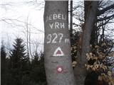
 | Hotovlja - Pasja ravan
Pasja ravan is the second-highest peak in the Polhograjsko hribovje. A few decades ago, at 1029 meters, it was the highest, but in the second hal...
1 h 45 min |
 | Potoče - Potoška gora
This forested peak is situated above Preddvor, between Javorov vrh and the Iskra na Jakobu mountain hut. The summit has a bench and a registratio...
2 h |
 | Spodnja Kokra - Potoška gora
This forested peak is situated above Preddvor, between Javorov vrh and the Iskra na Jakobu mountain hut. The summit has a bench and a registratio...
2 h 10 min |
 | Vrtovin - Kucelj (on Čaven)
Kucelj is located on the southern slopes of the Trnovski Forest, northwest of the Vipava Valley. From the bare summit, where a cross stands, ther...
2 h 15 min |
 | Senožeče - Vremščica
Vremščica is a mountain range stretching between Senožeče, Pivka and Divača. Its highest peak is Velika Vremščica. The view from the summit exten...
1 h 45 min |
 | Gornje Ležeče - Vremščica
Vremščica is a mountain range stretching between Senožeče, Pivka and Divača. Its highest peak is Velika Vremščica. The view from the summit exten...
1 h 40 min |
 | Podgora - Vremščica
Vremščica is a mountain range stretching between Senožeče, Pivka and Divača. Its highest peak is Velika Vremščica. The view from the summit exten...
2 h |
| Podmrzlica, Matke - Mrzlica
In recent years, Mrzlica has become an extremely popular excursion spot, especially for visitors from Savinjska valley and Zasavje. At 1,122 mete...
1 h 45 min |
 | Vrtovin - Mala gora
Mala gora is a plateau on the slope of Čavna. At 1034 meters' altitude, there is a hut. Mala gora is known for its flowers that are unique to thi...
2 h 15 min |
 | Gabrje - Trdinov vrh
Trdinov vrh is the highest point in the Gorjanci range. The view from the summit is poor due to the forest, but with good visibility, parts of th...
2 h |
 | Gradišče - Kremžarjev vrh
Kremžarjev vrh is the westernmost thousand-meter peak on Pohorje. It is located northeast of Slovenj Gradec. From the summit, which has a logbook...
1 h 55 min |
| Slovenj Gradec - Kremžarjev vrh
Kremžarjev vrh is the westernmost thousand-meter peak on Pohorje. It is located northeast of Slovenj Gradec. From the summit, which has a logbook...
2 h 15 min |
 | Podgorje - Slavnik (steep path)
Slavnik is a panoramic mountain rising south of Kozina and west of Podgorje. Podgorje is a suitable starting village for the ascent. At the summ...
1 h 15 min |
| Podgorje - Slavnik (gentle path)
Slavnik is a panoramic mountain rising south of Kozina and west of Podgorje. Podgorje is a suitable starting village for the ascent. At the summ...
1 h 40 min |
 | Skadanščina - Slavnik
Slavnik is a panoramic mountain rising south of Kozina and west of Podgorje. Podgorje is a suitable starting village for the ascent. At the summ...
1 h 40 min |
 | Skadanščina - Slavnik (via Planina Jegno)
Slavnik is a panoramic mountain rising south of Kozina and west of Podgorje. Podgorje is a suitable starting village for the ascent. At the summ...
2 h 10 min |
 | Prešnica - Slavnik
Slavnik is a panoramic mountain rising south of Kozina and west of Podgorje. Podgorje is a suitable starting village for the ascent. At the summ...
2 h |
 | Povžane - Slavnik
Slavnik is a panoramic mountain rising south of Kozina and west of Podgorje. Podgorje is a suitable starting village for the ascent. At the summ...
2 h 15 min |
 | Trpčane - Koča na Kozleku
The Koča na Kozleku mountain hut is situated southwest of Ilirska Bistrica, just a few meters below the summit of Kozlek. From the summit, there ...
1 h 45 min |
| Jablanica - Koča na Kozleku
The Koča na Kozleku mountain hut is situated southwest of Ilirska Bistrica, just a few meters below the summit of Kozlek. From the summit, there ...
1 h 45 min |
 | Jablanica - Srednji vrh at Kozlek
Srednji vrh pri Kozleku is a panoramic peak located west of Ilirska Bistrica, near the better-known Kozlek. From the summit, there is a beautiful...
1 h 25 min |
 | Rakov Škocjan - Veliki Javornik (Javorniki)
Veliki Javornik is a 1,268-meter-high peak of the forested hills named Javorniki. The extensive Javorniki forests stretch from Postojna to Cerkni...
2 h |
 | Ledinica - Sivka
Sivka is a forested peak located west of Žiri and north of Idrija. At the summit there is a stamp for the Slovenian Mountain Trail and a logbook ...
1 h 50 min |
| Žiri - Sivka
Sivka is a forested peak located west of Žiri and north of Idrija. At the summit there is a stamp for the Slovenian Mountain Trail and a logbook ...
2 h |
 | Idrija - Hleviška planina (hunting path)
Hleviška planina (also Hleviške planine) is a slightly vegetated but still very panoramic peak. From the summit, the home mountain of Idrija, the...
1 h 45 min |
 | Idrija - Hleviška planina (via Kodrov rovt)
Hleviška planina (also Hleviške planine) is a slightly vegetated but still very panoramic peak. From the summit, the home mountain of Idrija, the...
2 h |
 | Bohinjska Bela (Podklanec) - Galetovec (western way)
Galetovec is an indistinct peak on the southeastern part of the Pokljuka plateau. From the summit, which has a logbook, there is a nice view of t...
2 h |
 | Bohinjska Bela - Galetovec (via Turn)
Galetovec is an indistinct peak on the southeastern part of the Pokljuka plateau. From the summit, which has a logbook, there is a nice view of t...
2 h |
 | Spodnja Idrija - Jelenk (easy way)
Jelenk is a mountain between the valley of the Idrijca River, above which it rises steeply, and the valley of the Kanomljica River. From the summ...
2 h |
 | Brzika - Donačka gora
Donačka gora is a peak located north of Rogatec. From the summit, which geographically belongs to the Karawanks, there is a nice view of the near...
1 h 45 min |
| Sveti Jurij - Donačka gora (western path)
Donačka gora is a peak located north of Rogatec. From the summit, which geographically belongs to the Karawanks, there is a nice view of the near...
1 h 35 min |
 | Zabukovica - Gozdnik
Gozdnik is a hill that rises steeply above the village of Zabukovica. There is no view from the summit due to the forest, but a bivouac has been ...
2 h 5 min |
 | Pongrac (Hostage cemetery) - Gozdnik (past Petelinov vrh)
Gozdnik is a hill that rises steeply above the village of Zabukovica. There is no view from the summit due to the forest, but a bivouac has been ...
2 h |
| Pongrac (Hostage cemetery) - Gozdnik (past Mali Gozdnik)
Gozdnik is a hill that rises steeply above the village of Zabukovica. There is no view from the summit due to the forest, but a bivouac has been ...
2 h 5 min |
 | Slovenske Konjice - Stolpnik (via castle)
Stolpnik, at 1012 meters, is the highest peak of Konjiška gora, a range stretching southwest from Slovenske Konjice. A 25-meter-high observation ...
2 h 15 min |
 | Slovenske Konjice - Stolpnik (Zmajčkova pot)
Stolpnik, at 1012 meters, is the highest peak of Konjiška gora, a range stretching southwest from Slovenske Konjice. A 25-meter-high observation ...
1 h 45 min |
 | Črešnjice - Stolpnik
Stolpnik, at 1012 meters, is the highest peak of Konjiška gora, a range stretching southwest from Slovenske Konjice. A 25-meter-high observation ...
1 h 25 min |
 | Stranice - Stolpnik (via hunting cottage Štepih)
Stolpnik, at 1012 meters, is the highest peak of Konjiška gora, a range stretching southwest from Slovenske Konjice. A 25-meter-high observation ...
2 h 15 min |
| Spodnje Stranice (graves of hundred hostages) - Stolpnik (via hunting cottage Štepih)
Stolpnik, at 1012 meters, is the highest peak of Konjiška gora, a range stretching southwest from Slovenske Konjice. A 25-meter-high observation ...
2 h |
 | Spodnje Stranice (graves of hundred hostages) - Stolpnik (via Grofov štant)
Stolpnik, at 1012 meters, is the highest peak of Konjiška gora, a range stretching southwest from Slovenske Konjice. A 25-meter-high observation ...
2 h 10 min |
 | Žička kartuzija - Stolpnik (via Sojek and Vratca)
Stolpnik, at 1012 meters, is the highest peak of Konjiška gora, a range stretching southwest from Slovenske Konjice. A 25-meter-high observation ...
2 h 10 min |
| Žička kartuzija - Stolpnik (via Tri križi and Vratca)
Stolpnik, at 1012 meters, is the highest peak of Konjiška gora, a range stretching southwest from Slovenske Konjice. A 25-meter-high observation ...
2 h 15 min |
 | Jablance - Veliki Javornik (Bohor) (via Koprivnik)
Veliki Javornik, at 1023 meters, is the highest peak of Bohor. Although the summit is unvegetated and there are no higher hills nearby, there is ...
2 h |
 | Stara Žaga - Veliki Javornik (Bohor) (via Skalica)
Veliki Javornik, at 1023 meters, is the highest peak of Bohor. Although the summit is unvegetated and there are no higher hills nearby, there is ...
2 h 10 min |
 | Jablance - Veliki Javornik (Bohor) (via Koča na Bohorju)
Veliki Javornik, at 1023 meters, is the highest peak of Bohor. Although the summit is unvegetated and there are no higher hills nearby, there is ...
1 h 50 min |
 | Lašče - Sveti Peter
Sveti Peter is a partly forested peak in Suha Krajina above the village of Dvor. On the summit stands a small shelter (usually open on Sundays) a...
1 h 45 min |
 | Kopačnica - Ermanovec
Ermanovec is a 1,026-meter-high peak situated between Cerkno and Gorenja vas, more precisely above Sovodenj and Trebija. Just a few steps from th...
1 h 40 min |
 | Selca - Miklavška gora (footpath)
Miklavška gora is a panoramic hill situated south of Železniki and Selca. From the summit, where the Church of St. Nicholas stands, a beautiful v...
1 h 25 min |
 | Ribnica (Lepovče) - Stene svete Ane
Stene Svete Ane is a vegetated peak located near the Planinska Koča pri Sveti Ani on Mala Gora. A small observation tower stands on the summit, e...
1 h 35 min |
 | Gotenica - Kameni zid
Kameni zid consists of steep rocky cliffs descending sharply from Goteniška gora. From the top of Kameni zid, fine views open towards Stojna, Koč...
1 h 30 min |
 | Ernejčkov graben - Sivka
Sivka is a grassy peak at the far western end of Polhograjsko hribovje. On clear days, it offers breathtaking views from Snežnik across Javorniki...
2 h |
 | Hunting cottage Budanje - Kovk
Kovk is a panoramic peak west of Col on an elongated ridge rising steeply above the Vipava Valley. From the summit cross, beautiful views extend ...
1 h 30 min |
 | Kočevje - Mestni vrh (Kalan way)
Mestni vrh is a 1034 m high mountain located east of the Koča pri Jelenovem studencu hut. The summit, where there is a logbox with a stamp, offer...
1 h 30 min |
| Kočevje - Mestni vrh (Grajska way)
Mestni vrh is a 1034 m high mountain located east of the Koča pri Jelenovem studencu hut. The summit, where there is a logbox with a stamp, offer...
1 h 40 min |
 | Kočevje - Fridrihštajn Castle (Grajska way)
Fridrihštajn Castle, built in the 15th century, is located south of Kočevje on a 970 m high hill. Today only ruins remain, which have been renova...
1 h 30 min |
 | Kočevje - Livoldski vrh (Grajska way)
Livoldski vrh is a forest-covered hill located on the southeastern part of Stojna. The summit has a logbox and stamp....
1 h 45 min |
 | Kočevje - Požgani hrib (Kalan way)
Požgani hrib is a 1009 m high peak located in the heart of the extensive forests of Stojna. Mostly overgrown by forest, it offers only limited vi...
2 h |
| Kočevje - Požgani hrib (Grajska way)
Požgani hrib is a 1009 m high peak located in the heart of the extensive forests of Stojna. Mostly overgrown by forest, it offers only limited vi...
1 h 50 min |
 | Dol pri Hrastniku - Klobuk
Klobuk is a scenic peak located northeast of Hrastnik. From the summit, which has a logbox and stamp, there are fine views of the valley and surr...
2 h 10 min |
 | Dol pri Hrastniku - Kal (Kalski hrib)
Kal (Kalski hrib) is a 985 m high peak located between the better-known Mrzlica and the lesser-known Klobuk. From the summit, where there is a be...
2 h 10 min |
 | Bresternica (spodnji Rušnik) - Žavcarjev vrh
Žavcarjev vrh is a 915 m high mountain located north of the Drava River on the slopes of Kozjak. Since the summit is completely forested, there i...
1 h 40 min |
 | Socka - Špicasti vrh (Kislica)
Špicasti vrh, also known as Kislica (name of a small ridge south of Mala gora and the settlement Vitanje), is a 994 m hill between Vojnik and Str...
2 h 15 min |
 | Podbrdo - Kup
Kup is a 1,046-meter-high peak located between Petrovo Brdo and Podbrdo. From the summit, which features a cross and several transmitters, there ...
1 h 35 min |
 | Radlje ob Dravi - Kapunar / Kapunerkogel
Kapunar is a 1,051-meter-high peak above Radlje ob Dravi. Just below the summit stands an old customs post and border guardhouse, now used by ama...
2 h 15 min |
 | Trnovec - Gontarska planina
Gontarska Planina is a 894-meter-high hill located between Osolnik and Tošč. From the summit, which features two benches, a splendid view opens t...
1 h 30 min |
 | Blagovica - Špilk
Špilk is a 956 m high peak located north of Blagovica. At the mostly forested summit, PD Blagovica has set up a small bivouac with a bench and ta...
1 h 30 min |
 | Zazid - Golič
Golič is a grassy ridge extending from Kojnik to the Slovenian-Croatian border and continuing as the Žbevnica ridge on the Croatian side. Due to ...
1 h 30 min |
 | Kopačnica - Štor
Štor is a 1005 m high peak located directly above the Koča na Ermanovcu hut. The summit itself is forested, but from a meadow just a few dozen me...
1 h 25 min |
| Hotavlje - Štor (by road)
Štor is a 1005 m high peak located directly above the Koča na Ermanovcu hut. The summit itself is forested, but from a meadow just a few dozen me...
2 h 15 min |
 | Zgornja Besnica (Podrovnik) - Sveti Mohor (Zabrekve)
The Church of St. Mohor is located on a 952 m high hill between Zgornja Besnica and Selci. From the church or its nearby surroundings, there is a...
1 h 45 min |
 | Zazid - Nadglavinjak (via Lipnik)
Nadglavinjak is a lesser-known peak located southeast of Golič. From its indistinct grassy summit, nice views open up on Slavnik, Čičarija, Žbevn...
2 h 10 min |
 | Cerkno - Veliki vrh (Lajše)
Veliki vrh is an almost 900-meter-high elevation rising south of Cerkno. From the summit, which features several television and radio transmitter...
2 h |
 | Cerkno - Škofje
Škofje is a 973-meter-high peak located above the villages of Čeplez, Planina pri Cerknem, and Podpleče. The summit itself, marked by a small con...
1 h 45 min |
| Dolenji Novaki (Pod Kovkom) - Škofje
Škofje is a 973-meter-high peak located above the villages of Čeplez, Planina pri Cerknem, and Podpleče. The summit itself, marked by a small con...
2 h |
 | Ledinica - Loncmanova Sivka (Mrzli Vrh)
Loncmanova Sivka is a panoramic peak above the village Mrzli Vrh near Žiri. From the bare summit, on clear days, there are views of Golaki, Škofj...
1 h 35 min |
 | Žiri - Loncmanova Sivka (Mrzli Vrh)
Loncmanova Sivka is a panoramic peak above the village Mrzli Vrh near Žiri. From the bare summit, on clear days, there are views of Golaki, Škofj...
1 h 40 min |
 | Rakitnica - Bela stena
Bela stena (also known simply as Stene) is a scenic viewpoint west of Dolenja vas in the Ribniška valley, more precisely above Zadolje village. F...
2 h 10 min |
 | Vinska Gora - Ramšakov vrh (easy path)
Ramšakov vrh is the highest point of the circular path around Vinska Gora. At the 970 m high summit, next to the benches, there is also a stamp b...
2 h |
 | Vinska Gora - Ramšakov vrh (via farm Vodošek)
Ramšakov vrh is the highest point of the circular path around Vinska Gora. At the 970 m high summit, next to the benches, there is also a stamp b...
2 h |
 | Krače - Roviškovec (west path)
Roviškovec (also known as Roviški vrh) is a 930-meter-high peak located southeast of Zasavska Sveta gora. From the summit, which features a woode...
1 h 30 min |
 | Krače - Roviškovec (east path)
Roviškovec (also known as Roviški vrh) is a 930-meter-high peak located southeast of Zasavska Sveta gora. From the summit, which features a woode...
1 h 30 min |
 | Žovneško jezero - Grmada (Dobrovlje)
Grmada is a 898 m high, forest-covered peak located on the southeastern part of the Dobroveljska planota plateau. From the summit, where there is...
2 h 5 min |
 | Tržič - Veliki vrh above Završnik (via Kamnek)
Veliki vrh above Završnik is a 968 m high mountain located in the Pirmance ridge, north to northeast of Tržič. From the grassy summit, which feat...
1 h 45 min |
 | Matrafuered - Kékestető (pot modri križ)
Mátra is a hill range located 70 km east of Budapest. It hosts Hungary's two highest peaks: Kékes/Kekes at 1,014 m, the highest point in Hungary,...
2 h |
 | Matrafuered - Kékestető (Marijina pot)
Mátra is a hill range located 70 km east of Budapest. It hosts Hungary's two highest peaks: Kékes/Kekes at 1,014 m, the highest point in Hungary,...
2 h |
 | Matrafüred - Kékestető (pot modri trikotnik)
Mátra is a hill range located 70 km east of Budapest. It hosts Hungary's two highest peaks: Kékes/Kekes at 1,014 m, the highest point in Hungary,...
2 h |
 | Matrafüred - Kékestető (zelena pot)
Mátra is a hill range located 70 km east of Budapest. It hosts Hungary's two highest peaks: Kékes/Kekes at 1,014 m, the highest point in Hungary,...
2 h 15 min |
 | Gorenja vas - Javorč (via Jermanca)
Javorč is a 901-meter-high peak located northeast of Žiri. The summit, featuring a logbox with a logbook, lies at the edge of a larger clearing, ...
2 h |
| Dolenja Dobrava - Javorč
Javorč is a 901-meter-high peak located northeast of Žiri. The summit, featuring a logbox with a logbook, lies at the edge of a larger clearing, ...
1 h 30 min |
 | Lesično - Debeli vrh (Bohor)
Debeli vrh is a 921-meter-high peak on Bohor between Veliki Koprivnik and Oslica. Covered in dense forest, it offers no views. A marked hiking tr...
1 h 45 min |
 | Podvelka - Hlebov vrh (Rdeči Breg) (via Viltužnik)
Rdeči breg stretches between the Radoljna gorge to the east, the Drava to the north, and the Velka stream to the east. It is separated from the m...
2 h |
 | Janževski Vrh (Uran) - Hlebov vrh (Rdeči Breg)
Rdeči breg stretches between the Radoljna gorge to the east, the Drava to the north, and the Velka stream to the east. It is separated from the m...
1 h 30 min |
 | Hunting cottage Budanje - Kraguljc
Kraguljc is a mountain situated between Podrta gora and Sončnica. On the panoramic summit, from which nice views open towards the Vipava Valley a...
1 h 25 min |
 | Slovenska vas - Slovenski vrh
Slovenski vrh is a 1,041-meter-high mountain located in the ridge of Stojna, which lies between Kočevska Reka and Kočevje. The peak, a control po...
1 h 30 min |
 | Kočevje - Ledenik
Ledenik, at 1,072 meters, is the highest peak of Stojna, a forested ridge situated between Kočevje and Kočevska Reka. On the summit there is a lo...
2 h 15 min |
 | Terme Topolšica - Lomek (Lom)
Lom, with its highest peak Lomek (884 m), is a karst hill located above the tourist and health resort of Topolšica. From the summit there is an e...
1 h 50 min |
 | Terme Topolšica - Lomek (Lom) (hunting path)
Lom, with its highest peak Lomek (884 m), is a karst hill located above the tourist and health resort of Topolšica. From the summit there is an e...
1 h 50 min |
 | Paka pri Velenju - Visoko
Visoko is an easily accessible grassy plateau located south of Paški Kozjak. The summit features a monument to the fallen fighters of the 14th Di...
1 h 45 min |
 | Ledinica - Planinska koča Mrzl'k
The Planinska koča Mrzl'k mountain hut lies just a few meters below the Mrzlik summit. From the hut opens up a fine view of the neighboring Mrzli...
1 h 45 min |
| Žiri - Planinska koča Mrzl'k
The Planinska koča Mrzl'k mountain hut lies just a few meters below the Mrzlik summit. From the hut opens up a fine view of the neighboring Mrzli...
2 h |
 | Ledinica - Planinska koča Mrzl'k (via Jarčja Dolina)
The Planinska koča Mrzl'k mountain hut lies just a few meters below the Mrzlik summit. From the hut opens up a fine view of the neighboring Mrzli...
1 h 45 min |
 | Ravne na Koroškem - Šteharski vrh (Šteharnikov vrh)
Šteharski vrh (also Šteharnikov vrh or Črneška gora) is a 1,018 m high mountain located in the southeastern part of the Strojna range, between th...
1 h 45 min |
| Dravograd lake - Šteharski vrh (Šteharnikov vrh)
Šteharski vrh (also Šteharnikov vrh or Črneška gora) is a 1,018 m high mountain located in the southeastern part of the Strojna range, between th...
2 h 15 min |
 | Muta (Spodnja Muta) - Bricnik
Bricnik is a 1,017-meter-high peak located in the Kozjak hills above Muta. On the forested summit there is a logbox with logbook and stamp (the K...
1 h 50 min |
 | Volča - Malenski vrh
Malenski vrh is a 1,051-meter-high mountain located west of the settlement of Javorje. The summit features a small bench and a cairn, but the vie...
1 h 45 min |
 | Rein - Mühlbacher Kogel (Hunting path / Jägersteig)
Mühlbacher Kogel is a 1,050 m high mountain in the western part of the Graz Mountains in Styria.It is located above the Mühlbacher Hütte hut.From...
2 h 10 min |
 | Trebija - Vrhovski grič
Vrhovski Grič is a panoramic hill along the marked trail from Trebija to Ermanovec. From the grassy summit there is a fine view of the surroundin...
1 h 35 min |
 | Trebija - Vrhovski grič (via Sveti Pavel)
Vrhovski Grič is a panoramic hill along the marked trail from Trebija to Ermanovec. From the grassy summit there is a fine view of the surroundin...
1 h 45 min |
 | Velem - Irrotkő / Geschriebenstein (path blue plus)
Irrotkő is the highest peak of the Kőszeg Mountains (Kőszegi Hegység) and also the highest peak of western Hungary and the Austrian federal state...
1 h 45 min |
 | Hotavlje - Špik (Vranškov grič)
Špik (also marked as Vranškov grič on maps) is a 908 m high mountain west of Hotavlje. The summit lies in forest, but a grassy subpeak offers fin...
1 h 35 min |
 | Puščava - Klančnik (Glančnik)
Klančnik (Glančnik on some maps) is an 877-meter-high peak situated above the right bank of the Drava River, just a few minutes' walk from the Hu...
2 h 15 min |
| Lovrenc na Pohorju - Klančnik (Glančnik) (via Kapus)
Klančnik (Glančnik on some maps) is an 877-meter-high peak situated above the right bank of the Drava River, just a few minutes' walk from the Hu...
2 h |
 | Janževski Vrh (Uran) - Klančnik (Glančnik) (via Sveti Ignacij)
Klančnik (Glančnik on some maps) is an 877-meter-high peak situated above the right bank of the Drava River, just a few minutes' walk from the Hu...
2 h |
| HE Ožbalt - Klančnik (Glančnik)
Klančnik (Glančnik on some maps) is an 877-meter-high peak situated above the right bank of the Drava River, just a few minutes' walk from the Hu...
2 h 10 min |
 | Rein - Hochstein (Jägersteig)
Hochstein is a 925-meter-high mountain in the western part of the Graz Mountains in Styria. It is located northwest of the town Gratwein. A hunti...
1 h 30 min |
 | Deutschfeistritz - Schartnerkogel (on road)
Schartnerkogel is a 931-meter-high hill above the town Deutschfeistritz (Nemška Bistrica) in the western part of the Graz Mountains. A cross stan...
2 h |
 | Frohnleiten - Gschwendt (Gschwendtberg)
Gschwendt or Gschwendtberg is a 1,000-meter-high hill above the town of Frohnleiten in the eastern part of the Graz Mountains. Gschwendt has two ...
1 h 45 min |
 | Stubenbergsee - Kulm (via Kulmkögerl)
Kulm is a 975-meter-high panoramic peak located west of the town of Weiz. From the summit, where several sacred structures stand, a beautiful vie...
2 h |
 | Frohnleiten - Haneggkogel (panoramic path)
Haneggkogel is a 1089-meter-high hill above the town of Frohnleiten in the northwestern part of the Graz Mountains.On the summit stands a cross a...
2 h |
 | Frohnleiten - Hochtrötsch (Trötsch)
Hochtrötsch, or simply Trötsch, is a 1,239 m high hill and a popular hiking destination above the town of Frohnleiten in the Graz Mountains. In t...
2 h 15 min |
 | Laufnitzdorf - Schiffall
Schiffall is a 1,221 m high peak in the Graz Mountains. Together with the neighboring Kreuzkogel, it rises above the middle Mur Valley north of F...
2 h 15 min |
 | Bruck an der Mur - Hochanger (on road)
Brucker Hochanger (Hochanger) is a 1308 m high mountain in the Gleinalpe area. Together with Rennfeld and Madereck, it is one of the three local ...
2 h |
 | Selnica ob Dravi - Kranjčeva pečina
Kranjčeva pečina is located above the Kranjc homestead in the Kozjak range. A logbook box is on the panoramic cliff, with views mainly towards th...
2 h 10 min |
 | Podgorje ob Sevnični (Kurja vas) - Zaloška gora
Zaloška gora is a 930-meter-high panoramic peak on Bohor, from which a beautiful view opens up towards the east, south and partly west, while to ...
1 h 55 min |