 | Polhov Gradec (Božna) - Polhograjska Grmada (via Setnica)
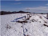
Polhograjska Grmada is an 898 m high peak located in the heart of the Polhograjski Dolomites. From the summit, where there is a registration box ...
1 h 30 min |
 | Belica - Polhograjska Grmada
Polhograjska Grmada is an 898 m high peak located in the heart of the Polhograjski Dolomites. From the summit, where there is a registration box ...
1 h 30 min |
 | Polhov Gradec - Polhograjska Grmada (via Ravnek and Mala Grmada)
Polhograjska Grmada is an 898 m high peak located in the heart of the Polhograjski Dolomites. From the summit, where there is a registration box ...
1 h 30 min |
 | Polhov Gradec (Božna) - Polhograjska Grmada (via Mačkov graben)
Polhograjska Grmada is an 898 m high peak located in the heart of the Polhograjski Dolomites. From the summit, where there is a registration box ...
1 h 30 min |
| Dvor - Polhograjska Grmada (via Mala Grmada)
Polhograjska Grmada is an 898 m high peak located in the heart of the Polhograjski Dolomites. From the summit, where there is a registration box ...
1 h 45 min |
 | Trnovec - Polhograjska Grmada
Polhograjska Grmada is an 898 m high peak located in the heart of the Polhograjski Dolomites. From the summit, where there is a registration box ...
1 h 15 min |
 | Polhov Gradec - Polhograjska Grmada (via Ravnek)
Polhograjska Grmada is an 898 m high peak located in the heart of the Polhograjski Dolomites. From the summit, where there is a registration box ...
1 h 30 min |
| Dvor - Polhograjska Grmada
Polhograjska Grmada is an 898 m high peak located in the heart of the Polhograjski Dolomites. From the summit, where there is a registration box ...
1 h 45 min |
 | Legastja - Sveti Jakob
The Church of St. James is located on a scenic hill north of the village of Topol pri Medvodah. From the summit, which features a registration bo...
1 h 10 min |
 | Preska - Sveti Jakob
The Church of St. James is located on a scenic hill north of the village of Topol pri Medvodah. From the summit, which features a registration bo...
1 h 45 min |
| Sora - Sveti Jakob
The Church of St. James is located on a scenic hill north of the village of Topol pri Medvodah. From the summit, which features a registration bo...
1 h 45 min |
 | Gabrje - Sveti Jakob
The Church of St. James is located on a scenic hill north of the village of Topol pri Medvodah. From the summit, which features a registration bo...
1 h 30 min |
 | Trnovec - Tošč
Tošč, which became the highest peak of the Polhov Gradec Hills decades ago when the Yugoslav army lowered Pasja ravan by 9 metres, is located nor...
1 h 35 min |
 | Petačev graben - Tošč (via Sveta Jedert)
Tošč, which became the highest peak of the Polhov Gradec Hills decades ago when the Yugoslav army lowered Pasja ravan by 9 metres, is located nor...
1 h 50 min |
 | Gabrovo - Lubnik
Lubnik is a 1025 m high mountain that rises steeply west of Škofja Loka. From the summit, where a mountain hut stands, there is a beautiful view ...
1 h 30 min |
 | Pirman - Kurešček
Kurešček is an 826 m high peak located south of Ig and southwest of Želimlje. From the summit, where a church stands, there is no view due to the...
1 h 45 min |
| Želimlje - Kurešček
Kurešček is an 826 m high peak located south of Ig and southwest of Želimlje. From the summit, where a church stands, there is no view due to the...
1 h 50 min |
 | Rakovica - Sveti Jošt above Kranj
Sveti Jošt above Kranj is a hill located west of the slightly lower Šmarjetna gora. From the summit, where the Church of St Jošt stands alongside...
1 h 20 min |
 | Tičnica - Sveti Jošt above Kranj (Pot prijateljev Sv. Jošta, on stairs)
Sveti Jošt above Kranj is a hill located west of the slightly lower Šmarjetna gora. From the summit, where the Church of St Jošt stands alongside...
1 h 15 min |
| Tičnica - Sveti Jošt above Kranj (Pot prijateljev Sv. Jošta, na klopca)
Sveti Jošt above Kranj is a hill located west of the slightly lower Šmarjetna gora. From the summit, where the Church of St Jošt stands alongside...
1 h 15 min |
| Tičnica - Sveti Jošt above Kranj (Pot prijateljev Sv. Jošta, past the chapel)
Sveti Jošt above Kranj is a hill located west of the slightly lower Šmarjetna gora. From the summit, where the Church of St Jošt stands alongside...
1 h 20 min |
 | Sora - Osolnik (by road)
Osolnik is an 858-metre-high mountain located south of Škofja Loka and west of Medvode. From the summit, where the Church of St Mohor and Fortuna...
1 h 40 min |
 | Sora - Osolnik (via Hom)
Osolnik is an 858-metre-high mountain located south of Škofja Loka and west of Medvode. From the summit, where the Church of St Mohor and Fortuna...
1 h 50 min |
| Trnovec - Osolnik (by road)
Osolnik is an 858-metre-high mountain located south of Škofja Loka and west of Medvode. From the summit, where the Church of St Mohor and Fortuna...
1 h 20 min |
 | Sora - Osolnik (on footpath)
Osolnik is an 858-metre-high mountain located south of Škofja Loka and west of Medvode. From the summit, where the Church of St Mohor and Fortuna...
1 h 35 min |
 | Trnovec - Osolnik (via Mavški graben)
Osolnik is an 858-metre-high mountain located south of Škofja Loka and west of Medvode. From the summit, where the Church of St Mohor and Fortuna...
1 h 15 min |
| Trnovec - Osolnik (via Govejski graben)
Osolnik is an 858-metre-high mountain located south of Škofja Loka and west of Medvode. From the summit, where the Church of St Mohor and Fortuna...
1 h 15 min |
 | Krače - Zasavska Sveta gora
Zasavska Sveta Gora is a popular excursion destination located between Litija and Izlake. From the summit, where the parish church of the Nativit...
1 h 15 min |
 | Slavkov dom na Golem brdu - Jeterbenk
Jeterbenk is a 774-meter-high peak located between the Slavkov dom hut on Golo Brdo and Katarina (the village of Topol). From the summit, where t...
1 h 15 min |
 | Gabrje - Jeterbenk
Jeterbenk is a 774-meter-high peak located between the Slavkov dom hut on Golo Brdo and Katarina (the village of Topol). From the summit, where t...
1 h 30 min |
 | Žlebe - Jeterbenk (on ridge)
Jeterbenk is a 774-meter-high peak located between the Slavkov dom hut on Golo Brdo and Katarina (the village of Topol). From the summit, where t...
1 h 5 min |
 | Legastja - Jeterbenk
Jeterbenk is a 774-meter-high peak located between the Slavkov dom hut on Golo Brdo and Katarina (the village of Topol). From the summit, where t...
1 h 40 min |
 | Polhov Gradec (Blagajev grad) - Polhograjska Gora (Sveti Lovrenc)
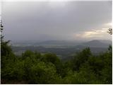
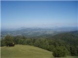
Polhograjska Gora, also known simply as Gora or Sveti Lovrenc, is an 824 m high hill northwest of Polhov Gradec. The summit, topped by the Church...
1 h 5 min |
 | Briše - Polhograjska Gora (Sveti Lovrenc) (gentle path)
Polhograjska Gora, also known simply as Gora or Sveti Lovrenc, is an 824 m high hill northwest of Polhov Gradec. The summit, topped by the Church...
1 h 35 min |
 | Zalog - Polhograjska Gora (Sveti Lovrenc) (gentle path)
Polhograjska Gora, also known simply as Gora or Sveti Lovrenc, is an 824 m high hill northwest of Polhov Gradec. The summit, topped by the Church...
1 h 30 min |
 | Polhov Gradec (Blagaj Castle) - Polhograjska Gora (Sveti Lovrenc) (via castle water catchment)
Polhograjska Gora, also known simply as Gora or Sveti Lovrenc, is an 824 m high hill northwest of Polhov Gradec. The summit, topped by the Church...
1 h 10 min |
| Polhov Gradec (Blagaj Castle) - Polhograjska Gora (Sveti Lovrenc) (by cart track)
Polhograjska Gora, also known simply as Gora or Sveti Lovrenc, is an 824 m high hill northwest of Polhov Gradec. The summit, topped by the Church...
1 h 15 min |
 | Vrzdenec - Kožljek
Kožljek is a 788 m high peak located west of Koren, more precisely above the village of Samotorica. From the summit, where there are several benc...
1 h 5 min |
 | Krašnja - Limbarska gora
Limbarska gora is located northeast of Moravče. From the summit, there is a beautiful view of the surrounding peaks, and in good weather, the Kam...
1 h 15 min |
 | Moravče - Limbarska gora (via Serjuče)
Limbarska gora is located northeast of Moravče. From the summit, there is a beautiful view of the surrounding peaks, and in good weather, the Kam...
1 h 25 min |
 | Moravče - Limbarska gora (via Gabrje)
Limbarska gora is located northeast of Moravče. From the summit, there is a beautiful view of the surrounding peaks, and in good weather, the Kam...
1 h 35 min |
 | Blagovica - Limbarska gora
Limbarska gora is located northeast of Moravče. From the summit, there is a beautiful view of the surrounding peaks, and in good weather, the Kam...
1 h 30 min |
| Lake Gradišče - Limbarska gora
Limbarska gora is located northeast of Moravče. From the summit, there is a beautiful view of the surrounding peaks, and in good weather, the Kam...
1 h 55 min |
 | Crngrob - Archangel Gabriel (Planica)
Planica is an 824-meter-high peak located north of Škofja Loka, more precisely between Križna gora and Planica. From the summit, where the church...
1 h 30 min |
 | Moškrin - Archangel Gabriel (Planica)
Planica is an 824-meter-high peak located north of Škofja Loka, more precisely between Križna gora and Planica. From the summit, where the church...
1 h 30 min |
 | Praprotno - Archangel Gabriel (Planica)
Planica is an 824-meter-high peak located north of Škofja Loka, more precisely between Križna gora and Planica. From the summit, where the church...
1 h 20 min |
 | Pevno - Archangel Gabriel (Planica)
Planica is an 824-meter-high peak located north of Škofja Loka, more precisely between Križna gora and Planica. From the summit, where the church...
1 h 30 min |
 | Senožeče - Vremščica
Vremščica is a mountain range stretching between Senožeče, Pivka and Divača. Its highest peak is Velika Vremščica. The view from the summit exten...
1 h 45 min |
 | Gornje Ležeče - Vremščica
Vremščica is a mountain range stretching between Senožeče, Pivka and Divača. Its highest peak is Velika Vremščica. The view from the summit exten...
1 h 40 min |
 | Blatni dol - Koča na Planini nad Vrhniko
Planina nad Vrhniko is for Vrhnika locals something like Šmarna gora for those from Ljubljana. It is 733 m high, reachable by several paths from ...
1 h 10 min |
 | Stara Vrhnika - Koča na Planini nad Vrhniko (via Kuren)
Planina nad Vrhniko is for Vrhnika locals something like Šmarna gora for those from Ljubljana. It is 733 m high, reachable by several paths from ...
1 h 15 min |
| Stara Vrhnika - Koča na Planini nad Vrhniko (via Špica)
Planina nad Vrhniko is for Vrhnika locals something like Šmarna gora for those from Ljubljana. It is 733 m high, reachable by several paths from ...
1 h 15 min |
 | Moravče - Sveti Miklavž above Sava
The Church of St. Miklavž is situated on a panoramic hill south of Moravče. From the summit, there is a beautiful view toward the nearby Limbarsk...
1 h 25 min |
 | Sveta Trojica - Cicelj
Cicelj is a forest-covered peak located between Moravče and the village of Senožeti. From the summit, which has a bench and a logbook box, there ...
1 h 45 min |
 | Podgorje - Slavnik (steep path)
Slavnik is a panoramic mountain rising south of Kozina and west of Podgorje. Podgorje is a suitable starting village for the ascent. At the summ...
1 h 15 min |
| Podgorje - Slavnik (gentle path)
Slavnik is a panoramic mountain rising south of Kozina and west of Podgorje. Podgorje is a suitable starting village for the ascent. At the summ...
1 h 40 min |
 | Skadanščina - Slavnik
Slavnik is a panoramic mountain rising south of Kozina and west of Podgorje. Podgorje is a suitable starting village for the ascent. At the summ...
1 h 40 min |
 | Zazid - Kojnik
Kojnik is a partly forested peak located in the southern part of Podgorski Kras near the Slovenian-Croatian border. From the summit, which has a ...
1 h 20 min |
 | Širje - Dom v Gorah
The Dom v Gorah mountain hut is located east of Hrastnik, just a few meters below the 786 m high peak where the church of St. Jurij stands. From ...
1 h 20 min |
 | Marno - Dom v Gorah
The Dom v Gorah mountain hut is located east of Hrastnik, just a few meters below the 786 m high peak where the church of St. Jurij stands. From ...
1 h 15 min |
 | Katarija - Slivna (Pivkelj)
Slivna, also known as Pivkelj (or Pivkelj turn), lies south of Limbarska gora. Pivkelj is the highest point of the Moravška planinska pot and at ...
1 h 55 min |
 | Trpčane - Koča na Kozleku
The Koča na Kozleku mountain hut is situated southwest of Ilirska Bistrica, just a few meters below the summit of Kozlek. From the summit, there ...
1 h 45 min |
| Jablanica - Koča na Kozleku
The Koča na Kozleku mountain hut is situated southwest of Ilirska Bistrica, just a few meters below the summit of Kozlek. From the summit, there ...
1 h 45 min |
 | Jablanica - Srednji vrh at Kozlek
Srednji vrh pri Kozleku is a panoramic peak located west of Ilirska Bistrica, near the better-known Kozlek. From the summit, there is a beautiful...
1 h 25 min |
 | Ledinica - Sivka
Sivka is a forested peak located west of Žiri and north of Idrija. At the summit there is a stamp for the Slovenian Mountain Trail and a logbook ...
1 h 50 min |
 | Idrija - Hleviška planina (hunting path)
Hleviška planina (also Hleviške planine) is a slightly vegetated but still very panoramic peak. From the summit, the home mountain of Idrija, the...
1 h 45 min |
 | Brzika - Donačka gora
Donačka gora is a peak located north of Rogatec. From the summit, which geographically belongs to the Karawanks, there is a nice view of the near...
1 h 45 min |
| Sveti Jurij - Donačka gora (western path)
Donačka gora is a peak located north of Rogatec. From the summit, which geographically belongs to the Karawanks, there is a nice view of the near...
1 h 35 min |
 | Rečica ob Paki - Gora Oljka
Gora Oljka is a hill located east of Šmartno ob Paki. On the summit stands the Church of the Holy Cross, built in the mid-18th century. Just a fe...
1 h 15 min |
 | Podgora - Gora Oljka (Martin way)
Gora Oljka is a hill located east of Šmartno ob Paki. On the summit stands the Church of the Holy Cross, built in the mid-18th century. Just a fe...
1 h 20 min |
 | Podvin pri Polzeli - Gora Oljka (upper path)
Gora Oljka is a hill located east of Šmartno ob Paki. On the summit stands the Church of the Holy Cross, built in the mid-18th century. Just a fe...
1 h 35 min |
| Podvin pri Polzeli - Gora Oljka (lower path)
Gora Oljka is a hill located east of Šmartno ob Paki. On the summit stands the Church of the Holy Cross, built in the mid-18th century. Just a fe...
1 h 30 min |
 | Matke - Golava
Golava is a peak located north of Mrzlica. From the summit, where there is a small bivouac (Blažev bivak), there is a fine view toward the aforem...
1 h 15 min |
 | Zabukovica - Kotečnik
Kotečnik is a peak in the Posavsko hribovje, located north of Šmohor. It is a summit with two logboxes: the first on the western subpeak, offerin...
1 h 30 min |
 | Liboje - Dom na Šmohorju (via organic farm Kralj)
The mountain hut Dom na Šmohorju is located between Laško, Liboje, and Zabukovica. From the hut, or from the church of St. Mohor just a few minut...
1 h 30 min |
 | Zgornja Rečica (church of Blessed Anton Martin Slomšek) - Dom na Šmohorju
The mountain hut Dom na Šmohorju is located between Laško, Liboje, and Zabukovica. From the hut, or from the church of St. Mohor just a few minut...
1 h 40 min |
 | Hayrack (Laška vas - Pečovje) - Tolsti vrh above Celjska koča (via chapel at Mary and on CPP)
Tolsti vrh (also recorded as Tovsti vrh in some sources) is situated above the Celjska koča ski area. The summit has a logbook box and stamp, but...
1 h 35 min |
 | Čretvež - Stolpnik (via Grofov štant)
Stolpnik, at 1012 meters, is the highest peak of Konjiška gora, a range stretching southwest from Slovenske Konjice. A 25-meter-high observation ...
1 h 35 min |
 | Čretvež - Stolpnik (via Hunting cottage Štepih)
Stolpnik, at 1012 meters, is the highest peak of Konjiška gora, a range stretching southwest from Slovenske Konjice. A 25-meter-high observation ...
1 h 25 min |
 | Črešnjice - Stolpnik
Stolpnik, at 1012 meters, is the highest peak of Konjiška gora, a range stretching southwest from Slovenske Konjice. A 25-meter-high observation ...
1 h 25 min |
 | Slovenske Konjice - Skala (gentle path)
Skala is a viewpoint on the eastern part of Konjiška gora. From this vantage point, equipped with a table, bench, and logbook box, there is a nic...
1 h 30 min |
 | Stara Žaga - Skalica (Bohor) (via Možnica)
Skalica is a lesser-known peak on the western part of Bohor. From the summit, which has a logbook box, there is a nice view to the south and west...
1 h 40 min |
 | Jablance - Veliki Javornik (Bohor) (via Koča na Bohorju)
Veliki Javornik, at 1023 meters, is the highest peak of Bohor. Although the summit is unvegetated and there are no higher hills nearby, there is ...
1 h 50 min |
 | Jablance - Koprivnik (Bohor)
Koprivnik, or Veliki Koprivnik, is one of numerous peaks on Bohor. It is located between Koča na Bohorju and Veliki Javornik. From the summit, wh...
1 h 20 min |
 | Lašče - Sveti Peter
Sveti Peter is a partly forested peak in Suha Krajina above the village of Dvor. On the summit stands a small shelter (usually open on Sundays) a...
1 h 45 min |
 | Mrzle doline - Sveti Peter
Sveti Peter is a partly forested peak in Suha Krajina above the village of Dvor. On the summit stands a small shelter (usually open on Sundays) a...
1 h 15 min |
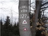
 | Gabrje - Rog
Rog is an 798-meter peak above the village of Topol, just 10 minutes from St. Katarina's Church. From the summit, where a large cross once stood,...
1 h 20 min |
| Preval - Rog
Rog is an 798-meter peak above the village of Topol, just 10 minutes from St. Katarina's Church. From the summit, where a large cross once stood,...
1 h 55 min |
 | Žlebe - Rog (via Turnice)
Rog is an 798-meter peak above the village of Topol, just 10 minutes from St. Katarina's Church. From the summit, where a large cross once stood,...
1 h 30 min |
| Žlebe - Rog (via Jeterbenk)
Rog is an 798-meter peak above the village of Topol, just 10 minutes from St. Katarina's Church. From the summit, where a large cross once stood,...
1 h 40 min |
 | Legastja - Rog
Rog is an 798-meter peak above the village of Topol, just 10 minutes from St. Katarina's Church. From the summit, where a large cross once stood,...
1 h 15 min |
 | Kopačnica - Ermanovec
Ermanovec is a 1,026-meter-high peak situated between Cerkno and Gorenja vas, more precisely above Sovodenj and Trebija. Just a few steps from th...
1 h 40 min |
 | Selca - Miklavška gora (footpath)
Miklavška gora is a panoramic hill situated south of Železniki and Selca. From the summit, where the Church of St. Nicholas stands, a beautiful v...
1 h 25 min |
 | Podgora - Grmada on Mala gora
Grmada (also Grmada above Ortnek) is an 887-meter-high peak located above the village of Vrh pri Poljanah in the Mala Gora range. Just a few mete...
1 h 20 min |
 | Ribnica (Lepovče) - Stene svete Ane
Stene Svete Ane is a vegetated peak located near the Planinska Koča pri Sveti Ani on Mala Gora. A small observation tower stands on the summit, e...
1 h 35 min |
 | Gotenica - Kameni zid
Kameni zid consists of steep rocky cliffs descending sharply from Goteniška gora. From the top of Kameni zid, fine views open towards Stojna, Koč...
1 h 30 min |
 | Hunting cottage Budanje - Kovk
Kovk is a panoramic peak west of Col on an elongated ridge rising steeply above the Vipava Valley. From the summit cross, beautiful views extend ...
1 h 30 min |
 | Kočevje - Mestni vrh (Kalan way)
Mestni vrh is a 1034 m high mountain located east of the Koča pri Jelenovem studencu hut. The summit, where there is a logbox with a stamp, offer...
1 h 30 min |
| Kočevje - Mestni vrh (Grajska way)
Mestni vrh is a 1034 m high mountain located east of the Koča pri Jelenovem studencu hut. The summit, where there is a logbox with a stamp, offer...
1 h 40 min |
 | Kočevje - Fridrihštajn Castle (Grajska way)
Fridrihštajn Castle, built in the 15th century, is located south of Kočevje on a 970 m high hill. Today only ruins remain, which have been renova...
1 h 30 min |
 | Kočevje - Livoldski vrh (Grajska way)
Livoldski vrh is a forest-covered hill located on the southeastern part of Stojna. The summit has a logbox and stamp....
1 h 45 min |
 | Kočevje - Požgani hrib (Grajska way)
Požgani hrib is a 1009 m high peak located in the heart of the extensive forests of Stojna. Mostly overgrown by forest, it offers only limited vi...
1 h 50 min |
 | Bresternica (spodnji Rušnik) - Žavcarjev vrh
Žavcarjev vrh is a 915 m high mountain located north of the Drava River on the slopes of Kozjak. Since the summit is completely forested, there i...
1 h 40 min |
 | Veliki Boč (Zgornji Kovač) - Žavcarjev vrh
Žavcarjev vrh is a 915 m high mountain located north of the Drava River on the slopes of Kozjak. Since the summit is completely forested, there i...
1 h 25 min |
 | Zgornja Rečica (church of Blessed Anton Martin Slomšek) - Govško brdo
Govško brdo is an 811-meter-high hill located west of the village of Huda Jama above Laško. From the summit, which features a logbook box and sta...
1 h 15 min |
 | Zgornja Rečica (Maček) - Govško brdo
Govško brdo is an 811-meter-high hill located west of the village of Huda Jama above Laško. From the summit, which features a logbook box and sta...
1 h 35 min |
 | Grčarevec - Grmada (Planinska gora) (Jakobova pot)
Grmada is an 873-meter-high peak rising west of Planinsko polje. Although the summit is forested, a viewpoint just below it offers a stunning vie...
1 h 50 min |
 | Borovnica - Mali Trebelnik
Mali Trebelnik is an 807-meter-high hill rising above the southwestern part of the Ljubljana Marshes. From the partly grassy summit, which is par...
1 h 30 min |
 | Potoška vas - Sveta planina (Partizanski vrh)
Sveta planina, also Partizanski vrh, is a 1,011-meter-high mountain located between Čemšeniška planina and Mrzlica. From the summit, where there ...
1 h 30 min |
 | Podbrdo - Kup
Kup is a 1,046-meter-high peak located between Petrovo Brdo and Podbrdo. From the summit, which features a cross and several transmitters, there ...
1 h 35 min |
 | Dvor - Mala Grmada
Mala Grmada is an 853-meter-high peak located southwest of the slightly higher Polhograjska Grmada. From the summit, a beautiful view opens up ov...
1 h 30 min |
 | Polhov Gradec (Božna) - Mala Grmada (via Setnica)
Mala Grmada is an 853-meter-high peak located southwest of the slightly higher Polhograjska Grmada. From the summit, a beautiful view opens up ov...
1 h 15 min |
 | Brod - Rudnica
Rudnica is a panoramic mountain located between the Lower and Upper Bohinj Valleys. From the summit, where there is a register box with a stamp a...
1 h 15 min |
 | Stara Fužina - Rudnica (by road)
Rudnica is a panoramic mountain located between the Lower and Upper Bohinj Valleys. From the summit, where there is a register box with a stamp a...
1 h 40 min |
 | Jezersko polje - Rudnica
Rudnica is a panoramic mountain located between the Lower and Upper Bohinj Valleys. From the summit, where there is a register box with a stamp a...
1 h 45 min |
 | Brod - Rudnica (via Široka polica)
Rudnica is a panoramic mountain located between the Lower and Upper Bohinj Valleys. From the summit, where there is a register box with a stamp a...
1 h 25 min |
| Savica - Rudnica
Rudnica is a panoramic mountain located between the Lower and Upper Bohinj Valleys. From the summit, where there is a register box with a stamp a...
1 h 15 min |
| Savica - Rudnica (via Široka polica)
Rudnica is a panoramic mountain located between the Lower and Upper Bohinj Valleys. From the summit, where there is a register box with a stamp a...
1 h 25 min |
 | Trnovec - Gontarska planina
Gontarska Planina is a 894-meter-high hill located between Osolnik and Tošč. From the summit, which features two benches, a splendid view opens t...
1 h 30 min |
 | Gabrje - Goljek
Goljek is an 809 m high peak located east of Polhograjska Grmada. From the summit, where remains of a former guard tower on the Italian-German bo...
1 h 40 min |
 | Blagovica - Špilk
Špilk is a 956 m high peak located north of Blagovica. At the mostly forested summit, PD Blagovica has set up a small bivouac with a bench and ta...
1 h 30 min |
 | Zazid - Golič
Golič is a grassy ridge extending from Kojnik to the Slovenian-Croatian border and continuing as the Žbevnica ridge on the Croatian side. Due to ...
1 h 30 min |
 | Kopačnica - Štor
Štor is a 1005 m high peak located directly above the Koča na Ermanovcu hut. The summit itself is forested, but from a meadow just a few dozen me...
1 h 25 min |
 | Zgornja Besnica (Podrovnik) - Sveti Mohor (Zabrekve)
The Church of St. Mohor is located on a 952 m high hill between Zgornja Besnica and Selci. From the church or its nearby surroundings, there is a...
1 h 45 min |
 | Zgornja Besnica (Podrovnik) - Špičasti hrib
Špičasti hrib (known as Špičasti vrh on maps) is an 837-meter-high hill located west of Sveti Jošt above Kranj. The summit, which has a few bench...
1 h 30 min |
 | Spodnja Besnica (fish farm) - Špičasti hrib
Špičasti hrib (known as Špičasti vrh on maps) is an 837-meter-high hill located west of Sveti Jošt above Kranj. The summit, which has a few bench...
1 h 30 min |
 | Zazid - Lipnik
Lipnik is an 804-meter-high peak located above the village Rakitovec on the Slovenian-Croatian border. From the summit, where a cross stands with...
1 h 40 min |
 | Kropa - Sveti Primož in Felicijan (Jamnik)
The Church of St. Primož and Felicijan at Jamnik is located on a scenic grassy ridge rising between Kropa and Podblica. From the church or its ne...
1 h 10 min |
 | Rovte - Sveti Primož in Felicijan (Jamnik)
The Church of St. Primož and Felicijan at Jamnik is located on a scenic grassy ridge rising between Kropa and Podblica. From the church or its ne...
1 h 15 min |
 | Češnjica pri Kropi - Sveti Primož in Felicijan (Jamnik)
The Church of St. Primož and Felicijan at Jamnik is located on a scenic grassy ridge rising between Kropa and Podblica. From the church or its ne...
1 h 15 min |
 | Ledinica - Loncmanova Sivka (Mrzli Vrh)
Loncmanova Sivka is a panoramic peak above the village Mrzli Vrh near Žiri. From the bare summit, on clear days, there are views of Golaki, Škofj...
1 h 35 min |
 | Žiri - Loncmanova Sivka (Mrzli Vrh)
Loncmanova Sivka is a panoramic peak above the village Mrzli Vrh near Žiri. From the bare summit, on clear days, there are views of Golaki, Škofj...
1 h 40 min |
 | Vinska Gora - Radojč (easy path)
Radojč is a 937 m high peak located north of Vinska gora. From the summit, which has a stamp box with logbook and stamp, there is no view due to ...
1 h 30 min |
 | Prelska - Vinska gora
Vinska gora (marked as the neighboring Temnjak on some maps) is an 806 m high hill located northwest of Dobrna and northeast of Vinska Gora. From...
1 h 20 min |
 | Krače - Roviškovec (west path)
Roviškovec (also known as Roviški vrh) is a 930-meter-high peak located southeast of Zasavska Sveta gora. From the summit, which features a woode...
1 h 30 min |
 | Krače - Roviškovec (east path)
Roviškovec (also known as Roviški vrh) is a 930-meter-high peak located southeast of Zasavska Sveta gora. From the summit, which features a woode...
1 h 30 min |
 | Krače - Pleše
Pleše is an 866-meter-high peak situated between the Marela ski slope and Zasavska Sveta gora. From the summit, which features a NOB monument, th...
1 h 45 min |
 | Letuš - Bezovec (Dobrovlje) (via hunting cottage)
Bezovec (Brezovec on some maps) is an 857-meter-high peak located west of Braslovško Lake, more precisely on the eastern part of the Dobrovlje Pl...
1 h 30 min |
 | Letuš - Bezovec (Dobrovlje) (via Covnikov križ)
Bezovec (Brezovec on some maps) is an 857-meter-high peak located west of Braslovško Lake, more precisely on the eastern part of the Dobrovlje Pl...
1 h 30 min |
 | Divje jezero - Zagrebenc
Zagrebenc (also Čekovnik on some maps) is a 763 m high peak located between Hleviška planina and the valley of the Idrijca River. From the grassy...
1 h 30 min |
 | Tržič - Veliki vrh above Završnik (via Kamnek)
Veliki vrh above Završnik is a 968 m high mountain located in the Pirmance ridge, north to northeast of Tržič. From the grassy summit, which feat...
1 h 45 min |
| Tržič - Veliki vrh above Završnik (below Kamnek)
Veliki vrh above Završnik is a 968 m high mountain located in the Pirmance ridge, north to northeast of Tržič. From the grassy summit, which feat...
1 h 40 min |
 | Greuth - Große Muschenig (via Maria Elender Alm)
Veliki Mošenik or Große Muschenig in German is a 1021 meters high peak situated on the Austrian side of the Karawanks, more precisely between Bis...
1 h 45 min |
| Greuth - Große Muschenig (via Hasengraben)
Veliki Mošenik or Große Muschenig in German is a 1021 meters high peak situated on the Austrian side of the Karawanks, more precisely between Bis...
1 h 45 min |
 | Dolenja Dobrava - Javorč
Javorč is a 901-meter-high peak located northeast of Žiri. The summit, featuring a logbox with a logbook, lies at the edge of a larger clearing, ...
1 h 30 min |
 | Lesično - Oslica (Bohor)
Oslica is one of Bohor's peaks, located in the eastern part of the range. Unlike some higher Bohor peaks such as Veliki Javornik, Koprivnik, Debe...
1 h 45 min |
 | Lesično - Debeli vrh (Bohor)
Debeli vrh is a 921-meter-high peak on Bohor between Veliki Koprivnik and Oslica. Covered in dense forest, it offers no views. A marked hiking tr...
1 h 45 min |
 | Jablance - Debeli vrh (Bohor)
Debeli vrh is a 921-meter-high peak on Bohor between Veliki Koprivnik and Oslica. Covered in dense forest, it offers no views. A marked hiking tr...
1 h 35 min |
 | Lesično - Brest (Bohor)
Brest is a peak on Bohor, though it resembles more of a saddle. It is an important trail junction on Bohor, lying between more easterly Oslica an...
1 h 30 min |
 | Jablance - Brest (Bohor) (via Koča na Bohorju)
Brest is a peak on Bohor, though it resembles more of a saddle. It is an important trail junction on Bohor, lying between more easterly Oslica an...
1 h 40 min |
 | Hunting cottage Budanje - Sončnica (Reber)
Sončnica is a paragliding site on the periphery of the Gora plateau or Reber ridge. At the take-off point, offering nice views towards the Vipava...
1 h 10 min |
 | Hunting cottage Budanje - Podrta gora above Ajdovščina
Podrta gora above Ajdovščina, also Podrta gora above Šturje, is a mountain rising above the Vipava Valley. Some time ago, a large piece of wall b...
1 h 35 min |
 | Hunting cottage Budanje - Kraguljc
Kraguljc is a mountain situated between Podrta gora and Sončnica. On the panoramic summit, from which nice views open towards the Vipava Valley a...
1 h 25 min |
 | Slovenska vas - Slovenski vrh
Slovenski vrh is a 1,041-meter-high mountain located in the ridge of Stojna, which lies between Kočevska Reka and Kočevje. The peak, a control po...
1 h 30 min |
 | Terme Topolšica - Lomek (Lom)
Lom, with its highest peak Lomek (884 m), is a karst hill located above the tourist and health resort of Topolšica. From the summit there is an e...
1 h 50 min |
 | Poljana - Volinjak (via Stovčnik)
Volinjak (wrongly named Volinjek on some maps) is an 886-meter-high peak located between Mežica and Prevalje. From the summit, which has a summit...
1 h 15 min |
| Poljana - Volinjak (via Leše churches and Prapar)
Volinjak (wrongly named Volinjek on some maps) is an 886-meter-high peak located between Mežica and Prevalje. From the summit, which has a summit...
1 h 25 min |
| Poljana - Volinjak (via Leše churches and Hermanko)
Volinjak (wrongly named Volinjek on some maps) is an 886-meter-high peak located between Mežica and Prevalje. From the summit, which has a summit...
1 h 25 min |
| Leše - Volinjak (via Hermanko)
Volinjak (wrongly named Volinjek on some maps) is an 886-meter-high peak located between Mežica and Prevalje. From the summit, which has a summit...
1 h 5 min |
| Leše - Volinjak (via Prapar)
Volinjak (wrongly named Volinjek on some maps) is an 886-meter-high peak located between Mežica and Prevalje. From the summit, which has a summit...
1 h 5 min |
 | Mežica - Volinjak
Volinjak (wrongly named Volinjek on some maps) is an 886-meter-high peak located between Mežica and Prevalje. From the summit, which has a summit...
1 h 10 min |
 | Paka pri Velenju - Visoko
Visoko is an easily accessible grassy plateau located south of Paški Kozjak. The summit features a monument to the fallen fighters of the 14th Di...
1 h 45 min |
 | Ledinica - Planinska koča Mrzl'k
The Planinska koča Mrzl'k mountain hut lies just a few meters below the Mrzlik summit. From the hut opens up a fine view of the neighboring Mrzli...
1 h 45 min |
 | Ledinica - Planinska koča Mrzl'k (via Jarčja Dolina)
The Planinska koča Mrzl'k mountain hut lies just a few meters below the Mrzlik summit. From the hut opens up a fine view of the neighboring Mrzli...
1 h 45 min |
 | Zalog - Planica (Paragliding site Gozd)
Planica is a 926-meter peak located above the village of Gozd. From the summit, where the JPK Kriška gora cottage stands, a nice view opens up ov...
1 h 30 min |
| Križe - Planica (Paragliding site Gozd)
Planica is a 926-meter peak located above the village of Gozd. From the summit, where the JPK Kriška gora cottage stands, a nice view opens up ov...
1 h 20 min |
| Tržič - Planica (Paragliding site Gozd)
Planica is a 926-meter peak located above the village of Gozd. From the summit, where the JPK Kriška gora cottage stands, a nice view opens up ov...
1 h 20 min |
 | Radlje ob Dravi - Sveti Trije Kralji (above Radlje ob Dravi)
The Church of the Holy Three Kings is located on an 820-meter-high hill rising above the right bank of the Radeljski Stream. From the church, a n...
1 h 40 min |
| Dolina Radeljskega potoka (Razdevšek) - Sveti Trije Kralji (above Radlje ob Dravi)
The Church of the Holy Three Kings is located on an 820-meter-high hill rising above the right bank of the Radeljski Stream. From the church, a n...
1 h 30 min |
 | Jablance - Grmada (Bohor)
The Grmada peak is situated on the slope of Bohor. The summit offers no views but is easily accessible. A partisan hospital is nearby....
1 h 20 min |
 | Dravograd (Meža) - Golarjev vrh
Golarjev vrh is an 843-meter-high forested peak located south to southeast of Cvitrško sedlo, which lies between Otiški vrh and Sveti Danijel....
1 h 50 min |
 | Škale - Lubela (via hunting lodge)
Lubela is a hill near Velenje that rises to the north above the Šaleška Valley and belongs to the Šentviško Hills or the broader Graška Gora area...
1 h 15 min |
 | Trebija - Vrhovski grič
Vrhovski Grič is a panoramic hill along the marked trail from Trebija to Ermanovec. From the grassy summit there is a fine view of the surroundin...
1 h 35 min |
 | Trebija - Vrhovski grič (via Sveti Pavel)
Vrhovski Grič is a panoramic hill along the marked trail from Trebija to Ermanovec. From the grassy summit there is a fine view of the surroundin...
1 h 45 min |
 | Predgrad - Kozice
Kozice is a 741-meter-high peak with an RTV transmitter located above the left bank of the Kolpa River. From the viewpoint on the southern subpea...
1 h 15 min |
| Predgrad - Kozice (by road)
Kozice is a 741-meter-high peak with an RTV transmitter located above the left bank of the Kolpa River. From the viewpoint on the southern subpea...
1 h 30 min |
 | Socka - Kozjek (above Socka)
Kozjek (above Socka) is an interesting peak located west of the ridged Kislica, like a sharpened extension of it with precipitous walls on its we...
1 h 10 min |
 | Hotavlje - Špik (Vranškov grič)
Špik (also marked as Vranškov grič on maps) is a 908 m high mountain west of Hotavlje. The summit lies in forest, but a grassy subpeak offers fin...
1 h 35 min |
 | Jablance - Plešivec (Bohor)
Plešivec, known on some maps as Špic hrib, is a 915-meter peak on Bohor located southeast of Koča na Bohorju....
1 h 5 min |
 | Oplotnica - Kebelj castle (Castle Zajec)
Kebeljski Castle or Zajčev Castle is situated on the eastern summit of Zajčev hrib, the hill above Kebelj....
1 h 25 min |
 | Zreče (Terme Zreče) - Golek
Golek is a 769-meter-high peak located northwest of Zreče. The summit has a logbook box with book and stamp, plus a bench; a short distance (a fe...
1 h 25 min |
| Zreče (Terme Zreče) - Golek (via Bork)
Golek is a 769-meter-high peak located northwest of Zreče. The summit has a logbook box with book and stamp, plus a bench; a short distance (a fe...
1 h 30 min |
| Zreče (Terme Zreče) - Golek (via Tourist farm Ančka)
Golek is a 769-meter-high peak located northwest of Zreče. The summit has a logbook box with book and stamp, plus a bench; a short distance (a fe...
1 h 35 min |
| Zreče (cemetery) - Golek
Golek is a 769-meter-high peak located northwest of Zreče. The summit has a logbook box with book and stamp, plus a bench; a short distance (a fe...
1 h 15 min |
 | Rein - Hochstein (Jägersteig)
Hochstein is a 925-meter-high mountain in the western part of the Graz Mountains in Styria. It is located northwest of the town Gratwein. A hunti...
1 h 30 min |
 | Deutschfeistritz - Gamskogel
Gamskogel is an 859-meter-high hill above the town of Deutschfeistritz (Nemška Bistrica) in Styria. A cross stands on the summit. There is no vie...
1 h 30 min |
 | Frohnleiten - Gschwendt (Gschwendtberg)
Gschwendt or Gschwendtberg is a 1,000-meter-high hill above the town of Frohnleiten in the eastern part of the Graz Mountains. Gschwendt has two ...
1 h 45 min |
 | Center Vintgar - Lookout point at Ančnikovo gradišče (via Bistriški vintgar)
The lookout platform is located near Ančnikovo gradišče. It offers a nice view. You can see the settlement of Slovenska Bistrica and its surroun...
1 h 30 min |
 | Stubenbergsee - Kulmkögerl (Kulmgipfel)
Kulmkögerl is an 866-meter-high peak located above Lake Stubenbergsee. A wooden cross stands on the summit, along with a summit logbook....
1 h 20 min |
 | Marno - Vrhe (at Gore)
Vrhe is a forested 781-meter-high peak located northwest of the Planinski dom hut in Gore....
1 h 25 min |
 | Kirchdorf - Predigtstuhl
Predigtstuhl is an 853 m high hill above the settlement of Kirchdorf in the northern part of the Grazer Bergland. At the summit, there is a cross...
1 h 30 min |
 | Rein - Pfaffenkogel
Pfaffenkogel is a 734 m high hill in the western part of the Grazer Bergland in Austrian Styria. The summit is located north of the town of Gratw...
1 h 30 min |
 | Podgorje ob Sevnični (Kurja vas) - Zaloška gora
Zaloška gora is a 930-meter-high panoramic peak on Bohor, from which a beautiful view opens up towards the east, south and partly west, while to ...
1 h 55 min |
 | Male Drage - Okrugljak
Okrugljak is a forested hill located in the eastern part of Gorski Kotar, near the border with Slovenia. The summit was formerly an HPO point (no...
1 h 30 min |
 | Sošice - Pliješ
Pliješ (Pleš on some maps) is a partially grassy summit above Sošice, near Slovenia, on Žumberačka gora. The summit is an HPO point, part of the ...
1 h 20 min |