 | Ravne - Črna prst (via Orožnova koča)
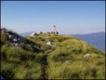
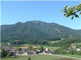
On the northern slope of the summit ridge of Črna prst, black soil is visible the feature after which the mountain is named. Črna prst is renown...
3 h 5 min |
 | Kocenpohar - Črna prst
On the northern slope of the summit ridge of Črna prst, black soil is visible the feature after which the mountain is named. Črna prst is renown...
2 h 45 min |
| Ravne - Črna prst (via planina za Črno goro)
On the northern slope of the summit ridge of Črna prst, black soil is visible the feature after which the mountain is named. Črna prst is renown...
3 h 25 min |
 | Kal - Črna prst
On the northern slope of the summit ridge of Črna prst, black soil is visible the feature after which the mountain is named. Črna prst is renown...
2 h 30 min |
 | Zalog - Tolsti vrh
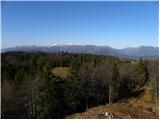
Tolsti vrh, located west of Storžič, is at 1715 metres also the highest peak of the Kriška gora range, which rises steeply above central Gorenjsk...
3 h 5 min |
 | Tržič - Tolsti vrh
Tolsti vrh, located west of Storžič, is at 1715 metres also the highest peak of the Kriška gora range, which rises steeply above central Gorenjsk...
3 h 15 min |
 | Golnik - Tolsti vrh (via Kriška goro)
Tolsti vrh, located west of Storžič, is at 1715 metres also the highest peak of the Kriška gora range, which rises steeply above central Gorenjsk...
3 h 30 min |
 | Golnik - Tolsti vrh (via Ježa)
Tolsti vrh, located west of Storžič, is at 1715 metres also the highest peak of the Kriška gora range, which rises steeply above central Gorenjsk...
3 h 15 min |
 | Križe - Tolsti vrh (steep path over Kriška gora)
Tolsti vrh, located west of Storžič, is at 1715 metres also the highest peak of the Kriška gora range, which rises steeply above central Gorenjsk...
3 h 40 min |
| Križe - Tolsti vrh (easier path over Kriška gora)
Tolsti vrh, located west of Storžič, is at 1715 metres also the highest peak of the Kriška gora range, which rises steeply above central Gorenjsk...
3 h 45 min |
| Križe - Tolsti vrh (via Ježa)
Tolsti vrh, located west of Storžič, is at 1715 metres also the highest peak of the Kriška gora range, which rises steeply above central Gorenjsk...
3 h 30 min |
| Gozd - Tolsti vrh (steep path over Kriška gora)
Tolsti vrh, located west of Storžič, is at 1715 metres also the highest peak of the Kriška gora range, which rises steeply above central Gorenjsk...
2 h 45 min |
| Povlje - Tolsti vrh
Tolsti vrh, located west of Storžič, is at 1715 metres also the highest peak of the Kriška gora range, which rises steeply above central Gorenjsk...
2 h 45 min |
 | Leskova dolina - Veliki Snežnik
Veliki Snežnik, at 1796 meters, is the highest peak in the nearby and distant surroundings, offering beautiful views over much of Slovenia and ne...
3 h 15 min |
 | Brezje pri Tržiču - Dobrča (on path Po robu and via Lešanska planina)
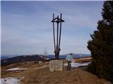
Dobrča is a 1634-metre mountain located between Begunje and Tržič. From the summit, which has a registration box with a stamp, the view opens onl...
2 h 35 min |
 | Brezje pri Tržiču - Dobrča (via koča na Dobrči)
Dobrča is a 1634-metre mountain located between Begunje and Tržič. From the summit, which has a registration box with a stamp, the view opens onl...
3 h |
| Brezje pri Tržiču - Dobrča (Po robu)
Dobrča is a 1634-metre mountain located between Begunje and Tržič. From the summit, which has a registration box with a stamp, the view opens onl...
2 h 30 min |
 | Zadnja vas - Dobrča
Dobrča is a 1634-metre mountain located between Begunje and Tržič. From the summit, which has a registration box with a stamp, the view opens onl...
3 h |
| Tržič - Dobrča
Dobrča is a 1634-metre mountain located between Begunje and Tržič. From the summit, which has a registration box with a stamp, the view opens onl...
3 h 10 min |
| Hudi Graben - Dobrča (via Koča na Dobrči)
Dobrča is a 1634-metre mountain located between Begunje and Tržič. From the summit, which has a registration box with a stamp, the view opens onl...
3 h |
 | Begunje (Preska) - Dobrča
Dobrča is a 1634-metre mountain located between Begunje and Tržič. From the summit, which has a registration box with a stamp, the view opens onl...
3 h |
 | Bistrica pri Tržiču - Dobrča
Dobrča is a 1634-metre mountain located between Begunje and Tržič. From the summit, which has a registration box with a stamp, the view opens onl...
2 h 55 min |
| Brezje pri Tržiču - Dobrča (by road)
Dobrča is a 1634-metre mountain located between Begunje and Tržič. From the summit, which has a registration box with a stamp, the view opens onl...
2 h 45 min |
 | Volaka - Blegoš
Blegoš is a 1,562-metre-high mountain located between the Selška Sora and Poljanska Sora rivers. From the grassy summit, where there is a stamp a...
2 h 35 min |
 | Zali Log - Blegoš (via Potok)
Blegoš is a 1,562-metre-high mountain located between the Selška Sora and Poljanska Sora rivers. From the grassy summit, where there is a stamp a...
3 h |
 | Petrovo Brdo - Možic (via Vrh Bače)
Možic is a 1,602 m high peak located west of Soriška Planina. At the very summit there is an old military bunker bearing the name of the peak and...
2 h 30 min |
| Petrovo Brdo - Možic (via Lajnar)
Možic is a 1,602 m high peak located west of Soriška Planina. At the very summit there is an old military bunker bearing the name of the peak and...
2 h 30 min |
| Podbrdo - Možic
Možic is a 1,602 m high peak located west of Soriška Planina. At the very summit there is an old military bunker bearing the name of the peak and...
3 h 15 min |
| Podbrdo - Možic (via Lajnar)
Možic is a 1,602 m high peak located west of Soriška Planina. At the very summit there is an old military bunker bearing the name of the peak and...
3 h 25 min |
 | Petrovo Brdo - Porezen
Porezen is a 1,630 m high mountain situated between Davča and Baška Grapa. From the summit, where a large Partisan monument stands, a beautiful v...
2 h 30 min |
 | Poče - Porezen (steep path)
Porezen is a 1,630 m high mountain situated between Davča and Baška Grapa. From the summit, where a large Partisan monument stands, a beautiful v...
2 h 30 min |
| Poče - Porezen (gentle path)
Porezen is a 1,630 m high mountain situated between Davča and Baška Grapa. From the summit, where a large Partisan monument stands, a beautiful v...
2 h 45 min |
 | Podbrdo - Porezen
Porezen is a 1,630 m high mountain situated between Davča and Baška Grapa. From the summit, where a large Partisan monument stands, a beautiful v...
3 h 30 min |
| Podbrdo - Porezen (via Dom na Poreznu)
Porezen is a 1,630 m high mountain situated between Davča and Baška Grapa. From the summit, where a large Partisan monument stands, a beautiful v...
3 h 35 min |
 | Jesenica - Porezen
Porezen is a 1,630 m high mountain situated between Davča and Baška Grapa. From the summit, where a large Partisan monument stands, a beautiful v...
2 h 55 min |
| Jesenica - Porezen (via Dom na Poreznu)
Porezen is a 1,630 m high mountain situated between Davča and Baška Grapa. From the summit, where a large Partisan monument stands, a beautiful v...
3 h |
| Preval Vrh Ravni - Porezen
Porezen is a 1,630 m high mountain situated between Davča and Baška Grapa. From the summit, where a large Partisan monument stands, a beautiful v...
2 h 30 min |
| Preval Vrh Ravni - Porezen (via Dom na Poreznu)
Porezen is a 1,630 m high mountain situated between Davča and Baška Grapa. From the summit, where a large Partisan monument stands, a beautiful v...
2 h 35 min |
 | Dolenji Novaki - Porezen
Porezen is a 1,630 m high mountain situated between Davča and Baška Grapa. From the summit, where a large Partisan monument stands, a beautiful v...
4 h |
| Poče - Porezen (via Labinjske lehe)
Porezen is a 1,630 m high mountain situated between Davča and Baška Grapa. From the summit, where a large Partisan monument stands, a beautiful v...
3 h 15 min |
| Poče - Porezen (winter way)
Porezen is a 1,630 m high mountain situated between Davča and Baška Grapa. From the summit, where a large Partisan monument stands, a beautiful v...
3 h 25 min |
 | Mače - Srednji vrh (via Kozjek and Dolga njiva)
Srednji vrh is an 1853 m high mountain located east of Storžič. From the summit, which features a bench, registration box and stamp, there is a b...
3 h 35 min |
| Mače - Srednji vrh (Mačenska pot and via Cjanovca)
Srednji vrh is an 1853 m high mountain located east of Storžič. From the summit, which features a bench, registration box and stamp, there is a b...
3 h 55 min |
| Mače - Srednji vrh (Mačenska pot and via Dolga njiva)
Srednji vrh is an 1853 m high mountain located east of Storžič. From the summit, which features a bench, registration box and stamp, there is a b...
3 h 40 min |
 | Stara Fužina - Pršivec (Direct way)
Pršivec is a panoramic mountain above Lake Bohinj. The view is extensive in all directions: Triglav and the surrounding mountains are clearly vis...
3 h 45 min |
 | Spodnja Kokra - Javorov vrh
Javorov Vrh (recorded in some sources as Javorjev Vrh) is a 1,434 m high mountain northeast of Preddvor. The summit, with its registration box an...
2 h 20 min |
 | Potoče - Javorov vrh (via Potoška gora)
Javorov Vrh (recorded in some sources as Javorjev Vrh) is a 1,434 m high mountain northeast of Preddvor. The summit, with its registration box an...
2 h 45 min |
| Potoče - Javorov vrh (direct way)
Javorov Vrh (recorded in some sources as Javorjev Vrh) is a 1,434 m high mountain northeast of Preddvor. The summit, with its registration box an...
2 h 30 min |
 | Mače - Javorov vrh (Mačenska pot)
Javorov Vrh (recorded in some sources as Javorjev Vrh) is a 1,434 m high mountain northeast of Preddvor. The summit, with its registration box an...
2 h 55 min |
| Mače - Javorov vrh (via Kozjek)
Javorov Vrh (recorded in some sources as Javorjev Vrh) is a 1,434 m high mountain northeast of Preddvor. The summit, with its registration box an...
3 h 10 min |
 | Mače - Bašeljski vrh
Bašeljski vrh is a 1744-meter-high mountain located between Mali Grintovec and Storžič. From the summit, where there is a bench and a registratio...
3 h 15 min |
| Laško (obračališče nad vasjo) - Bašeljski vrh
Bašeljski vrh is a 1744-meter-high mountain located between Mali Grintovec and Storžič. From the summit, where there is a bench and a registratio...
2 h 35 min |
| Bašelj - Bašeljski vrh (via hospital Košuta)
Bašeljski vrh is a 1744-meter-high mountain located between Mali Grintovec and Storžič. From the summit, where there is a bench and a registratio...
3 h 25 min |
| Bašelj - Bašeljski vrh
Bašeljski vrh is a 1744-meter-high mountain located between Mali Grintovec and Storžič. From the summit, where there is a bench and a registratio...
3 h 15 min |
| Mače - Bašeljski vrh (via Kozjek)
Bašeljski vrh is a 1744-meter-high mountain located between Mali Grintovec and Storžič. From the summit, where there is a bench and a registratio...
3 h 30 min |
 | MHE Zabukovec - Bašeljski vrh
Bašeljski vrh is a 1744-meter-high mountain located between Mali Grintovec and Storžič. From the summit, where there is a bench and a registratio...
3 h 10 min |
 | Dovje - Frauenkogel/Dovška Baba
Dovška Baba is a 1891-meter-high peak located on the border ridge between Slovenia and Austria. From the summit, which has a registration box and...
3 h |
 | Kraljev hrib - Konj
Konj is an 1803 m high peak located between Velika Planina and Presedljaj. From the summit there is a beautiful view of the highest peaks of the ...
3 h 30 min |
 | Petrovo Brdo - Slatnik (northwestern peak) (via Lajnar)
Slatnik is a panoramic mountain located west of the Soriška Planina ski resort. From its grassy summit there is a beautiful view of the Škofjeloš...
2 h 15 min |
 | Podbrdo - Slatnik (northwestern peak)
Slatnik is a panoramic mountain located west of the Soriška Planina ski resort. From its grassy summit there is a beautiful view of the Škofjeloš...
3 h 15 min |
| Podbrdo - Slatnik (northwestern peak) (via Lajnar)
Slatnik is a panoramic mountain located west of the Soriška Planina ski resort. From its grassy summit there is a beautiful view of the Škofjeloš...
3 h 10 min |
 | Grahovše - Bela peč (via Boršt)
The mountain, known mainly among climbers, is located north of Storžič on the slopes of Konjščica. From the summit there is a beautiful view of t...
2 h 30 min |
 | Grahovše - Bela peč (via rot)
The mountain, known mainly among climbers, is located north of Storžič on the slopes of Konjščica. From the summit there is a beautiful view of t...
2 h 30 min |
 | Grahovše - Bela peč (via Rekar)
The mountain, known mainly among climbers, is located north of Storžič on the slopes of Konjščica. From the summit there is a beautiful view of t...
2 h 30 min |
 | Tržič - Bela peč (via Potarje and Spodnja Konjščica)
The mountain, known mainly among climbers, is located north of Storžič on the slopes of Konjščica. From the summit there is a beautiful view of t...
3 h 55 min |
 | Mače - Mali Grintovec (via Kozjek and Dolga njiva)
Mali Grintovec is a panoramic mountain located east of Storžič. From the summit, which has a summit register box, stamp, and a pleasant bench, th...
3 h 35 min |
 | Laško (obračališče nad vasjo) - Mali Grintovec (via Bašeljski vrh)
Mali Grintovec is a panoramic mountain located east of Storžič. From the summit, which has a summit register box, stamp, and a pleasant bench, th...
3 h 20 min |
| Mače - Mali Grintovec (Mačenska pot and via Dolga njiva)
Mali Grintovec is a panoramic mountain located east of Storžič. From the summit, which has a summit register box, stamp, and a pleasant bench, th...
3 h 40 min |
| MHE Zabukovec - Mali Grintovec
Mali Grintovec is a panoramic mountain located east of Storžič. From the summit, which has a summit register box, stamp, and a pleasant bench, th...
3 h 55 min |
| Mače - Mali Grintovec (via Dom na Kališču)
Mali Grintovec is a panoramic mountain located east of Storžič. From the summit, which has a summit register box, stamp, and a pleasant bench, th...
3 h 50 min |
| Laško (obračališče nad vasjo) - Mali Grintovec (via Dom na Kališču)
Mali Grintovec is a panoramic mountain located east of Storžič. From the summit, which has a summit register box, stamp, and a pleasant bench, th...
3 h 10 min |
| Bašelj - Mali Grintovec (via Dom na Kališču)
Mali Grintovec is a panoramic mountain located east of Storžič. From the summit, which has a summit register box, stamp, and a pleasant bench, th...
3 h 50 min |
| Bašelj - Mali Grintovec (via hospital Košuta and Dom na Kališču)
Mali Grintovec is a panoramic mountain located east of Storžič. From the summit, which has a summit register box, stamp, and a pleasant bench, th...
4 h |
 | Rosenbach - Rosenkogel/Hruški vrh
Hruški vrh is a 1776-metre-high mountain located between Dovška Baba and the lesser-known Klek. From the summit, where there is a small chapel de...
3 h 50 min |
 | Rosenbach - Rosenkogel/Hruški vrh (via Koprivnjak)
Hruški vrh is a 1776-metre-high mountain located between Dovška Baba and the lesser-known Klek. From the summit, where there is a small chapel de...
4 h |
 | Podbrdo - Kobla
The summit is located in the Lower Bohinj Mountains between Črna prst and Soriška planina. Directly below it is a railway tunnel connecting Bohin...
3 h |
| Petrovo Brdo - Kobla
The summit is located in the Lower Bohinj Mountains between Črna prst and Soriška planina. Directly below it is a railway tunnel connecting Bohin...
2 h 15 min |
 | Mojstrana - Jerebikovec
The panoramic, slightly overgrown peak is located above Mojstrana and Radovna. From the summit, there is a beautiful view towards the Karawanks a...
2 h 20 min |
 | Zavrzelno - Čukla
Čukla is located above the Bovec Basin on the slopes of Rombon. From the summit, where there is a pyramid (monument commemorating the capture of ...
3 h |
 | Podbrdo - Lajnar
Lajnar is a 1,549-metre-high mountain located north of Soriška Planina. From the summit, which is also the highest point of the ski resort, a bea...
2 h 55 min |
 | Petrovo Brdo - Šavnik
Šavnik is a grassy peak situated between the ski resorts of Soriška Planina and Kobla. From the summit, which has a registration box with a stamp...
2 h 15 min |
| Podbrdo - Šavnik
Šavnik is a grassy peak situated between the ski resorts of Soriška Planina and Kobla. From the summit, which has a registration box with a stamp...
3 h |
 | Zali Log - Koprivnik
Koprivnik is a 1393-meter-high mountain located between Blegoš and Mladi vrh. From the summit, which has a registration box and a stamp, the view...
2 h 45 min |
| Javorje - Koprivnik (via Brdo)
Koprivnik is a 1393-meter-high mountain located between Blegoš and Mladi vrh. From the summit, which has a registration box and a stamp, the view...
2 h 20 min |
 | Lipa - Vivodnik
Vivodnik, at 1508 meters, is the highest peak of Menina planina, a plateau rising south of Gornji Grad. From the summit, which has a small observ...
3 h 30 min |
 | Golice - Vivodnik
Vivodnik, at 1508 meters, is the highest peak of Menina planina, a plateau rising south of Gornji Grad. From the summit, which has a small observ...
2 h 45 min |
 | Tirosek (Nova Štifta) - Vivodnik
Vivodnik, at 1508 meters, is the highest peak of Menina planina, a plateau rising south of Gornji Grad. From the summit, which has a small observ...
4 h |
 | Mojstrana - Vrtaški vrh
Vrtaški Vrh is a panoramic mountain above Vrata Valley. From the grassy peak, surrounded by dwarf pines, there is a nice view toward the neighbor...
3 h 40 min |
 | Ljubenske Rastke (Kumprej) - Smrekovec
Smrekovec is a mountain of volcanic origin on the eastern edge of the Smrekovec mountain range. The wide grassy summit features a pyramid with a ...
2 h 10 min |
 | Javorje (Mala Črna) - Smrekovec (via Bukov stan)
Smrekovec is a mountain of volcanic origin on the eastern edge of the Smrekovec mountain range. The wide grassy summit features a pyramid with a ...
3 h 15 min |
| Javorje (Mala Črna) - Smrekovec (by road)
Smrekovec is a mountain of volcanic origin on the eastern edge of the Smrekovec mountain range. The wide grassy summit features a pyramid with a ...
3 h 15 min |
 | Ljubenske Rastke - Komen
At 1684 meters, Komen is the highest peak in the Smrekovec mountain range, which borders between Styria and Carinthia. In good weather, the summi...
3 h 15 min |
 | Valley of stream Žep - Veliki Travnik (Turnovka)
Veliki Travnik, also known as Turnovka by the locals, is located on the western edge of the Smrekovec mountain range. From the summit, which has ...
2 h 45 min |
 | Bistra - Veliki Travnik (Turnovka)
Veliki Travnik, also known as Turnovka by the locals, is located on the western edge of the Smrekovec mountain range. From the summit, which has ...
3 h 45 min |
| Ljubno ob Savinji - Veliki Travnik (Turnovka)
Veliki Travnik, also known as Turnovka by the locals, is located on the western edge of the Smrekovec mountain range. From the summit, which has ...
4 h |
 | Robanov kot - Strelovec
This scenic peak is situated between two Alpine valleys: Logarska dolina and Robanov kot. The view from the summit is most beautiful towards the ...
3 h |
 | Spodnja Kokra - Cjanovca
Cjanovca is a peak east of Storžič and south of Srednji vrh. It is clearly visible from Kranj and its surroundings. The southern slope is bare, w...
3 h 50 min |
| Mače - Cjanovca (Mačenska pot and on SE ridge)
Cjanovca is a peak east of Storžič and south of Srednji vrh. It is clearly visible from Kranj and its surroundings. The southern slope is bare, w...
3 h 40 min |
| Mače - Cjanovca (over Kozjek and on SE ridge)
Cjanovca is a peak east of Storžič and south of Srednji vrh. It is clearly visible from Kranj and its surroundings. The southern slope is bare, w...
3 h 55 min |
| Mače - Cjanovca (Mačenska pot and via Dolga njiva)
Cjanovca is a peak east of Storžič and south of Srednji vrh. It is clearly visible from Kranj and its surroundings. The southern slope is bare, w...
3 h 35 min |
| Mače - Cjanovca (via Kozjek and Dolga njiva)
Cjanovca is a peak east of Storžič and south of Srednji vrh. It is clearly visible from Kranj and its surroundings. The southern slope is bare, w...
3 h 30 min |
 | Vitanje - Rogla
Rogla is a peak in the middle of the eponymous ski resort. The peak is forested with a small clearing on which stands a lookout tower. The tower ...
4 h |
 | Gorenje pri Zrečah - Rogla
Rogla is a peak in the middle of the eponymous ski resort. The peak is forested with a small clearing on which stands a lookout tower. The tower ...
2 h 35 min |
 | Lovrenc na Pohorju - Lovrenška jezera
The Lovrenška jezera are located on a high bog in the middle of Pohorje between Rogla and Ribniško Pohorje. The smaller lakes, which receive wate...
3 h 35 min |
 | Mislinja - Mali Črni vrh
Mali Črni vrh is located above the Ribniška koča mountain hut. At the top, there is an artificial lake intended for snowmaking. From the top, the...
2 h 55 min |
 | Mislinja - Črni vrh
Črni vrh is the highest peak of Pohorje. Because it is partly unvegetated, it offers a nice view toward Velika Kopa, Uršlja gora, and in the back...
2 h 30 min |
 | Dovže - Črni vrh
Črni vrh is the highest peak of Pohorje. Because it is partly unvegetated, it offers a nice view toward Velika Kopa, Uršlja gora, and in the back...
3 h 45 min |
 | Dovže - Velika Kopa
Velika Kopa is a 1542-meter-high peak located between Grmovškov dom and the nearby Mala Kopa. From the top, which is only 1 meter lower than the ...
3 h 15 min |
 | Poštarski dom pod Plešivcem - Uršlja gora (Plešivec) (via Kozarnica)
Uršlja gora, or Plešivec, is a panoramic mountain between Slovenj Gradec and Črna na Koroškem. At or just below the summit stands the Church of S...
2 h 30 min |
| Poštarski dom pod Plešivcem - Uršlja gora (Plešivec) (via Kal)
Uršlja gora, or Plešivec, is a panoramic mountain between Slovenj Gradec and Črna na Koroškem. At or just below the summit stands the Church of S...
2 h 45 min |
 | Ivarčko jezero - Uršlja gora (Plešivec) (Železarska pot)
Uršlja gora, or Plešivec, is a panoramic mountain between Slovenj Gradec and Črna na Koroškem. At or just below the summit stands the Church of S...
2 h 45 min |
 | Ivarčko jezero - Uršlja gora (Plešivec) (via Kozji hrbet)
Uršlja gora, or Plešivec, is a panoramic mountain between Slovenj Gradec and Črna na Koroškem. At or just below the summit stands the Church of S...
3 h |
 | Žerjav - Uršlja gora (Plešivec)
Uršlja gora, or Plešivec, is a panoramic mountain between Slovenj Gradec and Črna na Koroškem. At or just below the summit stands the Church of S...
3 h 15 min |
 | Učja - Monte Guarda/Skutnik
Skutnik is a peak situated north of the Učja River on the border with Italy. From the top, there is a beautiful view of the Kanin mountain group,...
3 h 45 min |
 | Drežniške Ravne - Krasji vrh (via snežna jama)
Krasji vrh is situated between Bovec and Kobarid on the Polovnik mountain ridge. At 1773 m it is also the highest peak of the mentioned ridge, so...
3 h |
 | Valbruna/Ovčja vas - Svete Višarje / Monte Lussari
Svete Višarje / Monte Lussari is a pilgrimage site for Slavs, Germans, and Romance peoples. Already in the 16th century, the mountain was called ...
2 h 30 min |
 | Podpeca (Helenski potok) - Mala Peca (via Mirjanca)
Mala Peca is the peak above the Dom na Peci mountain hut on its eastern slopes. From the summit, where a panoramic sign stands, there is a nice v...
3 h 20 min |
| Topla (Burjak) - Mala Peca
Mala Peca is the peak above the Dom na Peci mountain hut on its eastern slopes. From the summit, where a panoramic sign stands, there is a nice v...
2 h 30 min |
 | Bad Vellach - Kärntner Storschitz / Pristovški Storžič
Pristovški Storžič (Kärntner Storschitz) is an exceptionally panoramic peak above Jezersko. From it, there are fine views of the northern walls o...
2 h 30 min |
 | Jasna - Ciprnik (via Mojčin dom)
A hidden yet scenic peak above the Kranjska Gora ski slopes. To the east are the Martuljek Mountains; on the other side, Jalovec, Ponce, and Mojs...
3 h |
| Kranjska Gora - Ciprnik (via Bedančev dom)
A hidden yet scenic peak above the Kranjska Gora ski slopes. To the east are the Martuljek Mountains; on the other side, Jalovec, Ponce, and Mojs...
2 h 55 min |
 | Waidisch / Bajdiše - Ferlacher Horn / Grlovec
Grlovec/Ferlacher Horn is a panoramic mountain on which a large cross stands. From the top, there is a beautiful view of the Karawanks, parts of ...
3 h 35 min |
| Deutcher Peter / Dajčpeter - Ferlacher Horn / Grlovec
Grlovec/Ferlacher Horn is a panoramic mountain on which a large cross stands. From the top, there is a beautiful view of the Karawanks, parts of ...
3 h |
 | Podbrdo - Krevl
Krevl is a 1515-meter-high peak situated south of the Kobla ski area, more precisely between the Kobla peak and Kravja Črna gora. From the summit...
3 h 15 min |
| Petrovo Brdo - Krevl
Krevl is a 1515-meter-high peak situated south of the Kobla ski area, more precisely between the Kobla peak and Kravja Črna gora. From the summit...
2 h 30 min |
 | Ravne - Krevl
Krevl is a 1515-meter-high peak situated south of the Kobla ski area, more precisely between the Kobla peak and Kravja Črna gora. From the summit...
2 h 20 min |
| Bohinjska Bistrica - Krevl (via Planina za Črno goro)
Krevl is a 1515-meter-high peak situated south of the Kobla ski area, more precisely between the Kobla peak and Kravja Črna gora. From the summit...
2 h 55 min |
 | Masseris - Monte Mataiur/Matajur
Matajur is a panoramic mountain located on the border between Slovenia and Italy. From the summit there is a beautiful view of Kobariški or Bregi...
2 h 30 min |
 | Livek - Monte Mataiur/Matajur
Matajur is a panoramic mountain located on the border between Slovenia and Italy. From the summit there is a beautiful view of Kobariški or Bregi...
3 h |
 | Bistrica v Rožu / Feistritz im Rosental - Sinacher Gupf / Psinski vrh (west path)
Sinski vrh (mostly marked as Psinski vrh on maps) / Sinacher Gupf is a peak north of the main Karawanks ridge, more precisely north of Stol and V...
3 h 15 min |
| Bistrica v Rožu / Feistritz im Rosental - Sinacher Gupf / Psinski vrh (east path)
Sinski vrh (mostly marked as Psinski vrh on maps) / Sinacher Gupf is a peak north of the main Karawanks ridge, more precisely north of Stol and V...
3 h 15 min |
 | Trnje / Dornach - Singerberg / Žingarica
Žingarica / Singerberg is a peak on the Austrian side of the Karawanks above the village of Slovenji Plajberk / Windisch Bleiberg. From the summi...
3 h 20 min |
 | Bistrica v Rožu / Feistritz im Rosental - Singerberg / Žingarica
Žingarica / Singerberg is a peak on the Austrian side of the Karawanks above the village of Slovenji Plajberk / Windisch Bleiberg. From the summi...
3 h 55 min |
 | Glavaš - Dinara (past cotage Drago Grubać)
Vrh Sinjal or Dinara (1831 m) is the highest peak in Croatia. From the summit, where there is a summit register and a cross, there is a nice view...
4 h |
 | Žekovec - Boskovec (via Verbučeva planina)
Boskovec is with 1587 m the highest peak of the Golte plateau. From the top on which a lookout tower stands, a view opens up on part of Kamnik Sa...
3 h |
 | Žekovec - Boskovec (past Keber and Mozirska koča)
Boskovec is with 1587 m the highest peak of the Golte plateau. From the top on which a lookout tower stands, a view opens up on part of Kamnik Sa...
3 h 20 min |
 | Radegunda (Žekovec) - Boskovec (through Zagradiška puša and on path Severjeva pot)
Boskovec is with 1587 m the highest peak of the Golte plateau. From the top on which a lookout tower stands, a view opens up on part of Kamnik Sa...
3 h 10 min |
| Radegunda (Žekovec) - Boskovec (via Zagradiška puša and Hleviška planina)
Boskovec is with 1587 m the highest peak of the Golte plateau. From the top on which a lookout tower stands, a view opens up on part of Kamnik Sa...
3 h 15 min |
 | Dom v Lepeni - Mali Šmohor
Mali Šmohor is a panoramic peak located southeast of Krnsko Jezero lake. From the summit, which has a logbook, there are nice views of nearby pea...
4 h |
 | Ljubenske Rastke - Bezovec
Bezovec is a lesser-known peak located in Smrekovško pogorje. From the summit, where a hunting observatory stands, a nice view opens up mainly on...
2 h 15 min |
 | Razdrto - Suhi vrh (Nanos) (gentle path)
Suhi vrh is the highest peak of the mighty karst plateau Nanos at 1313 meters. Although Pleša with its transmitters and Vojko's hut is more popul...
4 h |
 | Jesenice (Ukova) - Španov vrh (Čez sedem grabnov)
Španov vrh is a 1334-meter-high mountain in the Karavanke that rises between Javorniški Rovt and Planina pod Golico. From the scenic summit, acce...
2 h 30 min |
 | Rosenbach - Kleiner Frauenkogel/Koprivnjak
Koprivnjak (Mala Dovška Baba) is a 1754 m high peak on the Austrian side of the Karawanks. From the summit, where a cross and summit logbook stan...
3 h 30 min |
 | Zali Log - Gladki vrh (Ratitovec)
Gladki vrh (Ratitovec), at 1,667 meters, is the most visited peak in the Ratitovec range. From its bare summit, which features a panorama board, ...
3 h 5 min |
 | Rudenska grapa - Gladki vrh (Ratitovec)
Gladki vrh (Ratitovec), at 1,667 meters, is the most visited peak in the Ratitovec range. From its bare summit, which features a panorama board, ...
4 h |
 | Podrošt - Gladki vrh (Ratitovec)
Gladki vrh (Ratitovec), at 1,667 meters, is the most visited peak in the Ratitovec range. From its bare summit, which features a panorama board, ...
3 h 5 min |
 | Podrošt - Altemaver (Ratitovec)
Altemaver (Ratitovec), at 1,678 meters, is the highest peak of Ratitovec. From its grassy summit, there is a beautiful view of the Julian Alps, J...
3 h 20 min |
 | Trdnjava Kluže - Kota 1313
Kota 1313 was an Austro-Hungarian artillery observation post during World War I. From position 1313, located near the indistinct summit of Veliki...
2 h 20 min |
 | Montemaggiore - Punta di Montemaggiore
Breški Jalovec, or Punta di Montemaggiore in Italian, is a 1613-meter-high mountain located above the source of the Nadiža River, specifically on...
3 h |
 | Zrmanja Railway Station - Poštak
Poštak (also "Kečina kosa") is a scenic mountain at the junction of Lika and Dalmatia. It belongs to the Lička Plješivica range as an extension, ...
2 h 30 min |
 | Susalitch - Zajčnik
Zajčnik (also Blekova) is a 1746-meter-high peak situated northeast of Vošca. From the partly vegetated summit, which borders Slovenia and Austri...
3 h 35 min |
| Korpitch - Zajčnik
Zajčnik (also Blekova) is a 1746-meter-high peak situated northeast of Vošca. From the partly vegetated summit, which borders Slovenia and Austri...
3 h 35 min |
 | Planina Polog - Mrzli vrh above Planina Pretovč
Mrzli vrh is a well-known battlefield from the First World War. Today, the peak is recognised as an open-air museum where numerous caverns, trenc...
2 h 45 min |
 | Ukanc - Visoki Orlov rob (via Žagarjev graben)
Visoki Orlov rob is a 1,800-meter-high peak located right next to the upper station of the Šija single-chair lift. From the summit, which lies sl...
3 h 45 min |
 | Dolenji Novaki - Medrce
Medrce is a 1,410-meter-high peak located between Porezen and Hum. From the summit, which features an old bunker, there are nice views of Kojca, ...
3 h 15 min |
| Poče - Medrce (winter way)
Medrce is a 1,410-meter-high peak located between Porezen and Hum. From the summit, which features an old bunker, there are nice views of Kojca, ...
2 h 40 min |
| Poče - Medrce (via Labinjske lehe)
Medrce is a 1,410-meter-high peak located between Porezen and Hum. From the summit, which features an old bunker, there are nice views of Kojca, ...
2 h 30 min |
 | Poče - Kopa (Cimprovka) (winter way)
Kopa is a 1360 m high peak or panoramic promontory from which a nice view opens up on Cerkno, the hills surrounding it, Ratitovec, Trnovski gozd,...
2 h 25 min |
 | Podbrdo - Slatnik (southeastern peak)
Slatnik (southeastern peak) is a panoramic mountain that rises steeply above Baška grapa on one side and descends more gently toward Soriška plan...
3 h 25 min |
| Podbrdo - Slatnik (southeastern peak) (via Lajnar)
Slatnik (southeastern peak) is a panoramic mountain that rises steeply above Baška grapa on one side and descends more gently toward Soriška plan...
3 h |
 | Podrožca / Rosenbach - Kamnica (Komnica) / Ferlacher Spitze
Kamnica is a panoramic mountain on the Austrian side of the Karawanks, more precisely north of Kepa. From the summit, which has a cross, summit r...
3 h 55 min |
| Čemernica / Tschemernitzen - Kamnica (Komnica) / Ferlacher Spitze
Kamnica is a panoramic mountain on the Austrian side of the Karawanks, more precisely north of Kepa. From the summit, which has a cross, summit r...
3 h 40 min |
 | Bistriški jarek (border crossing Muta) - Kozji vrh (at Košenjak)
Kozji vrh is a 1,383-meter-high peak located above Pernice; it is also the highest peak in the Municipality of Muta....
2 h 50 min |
 | Veliko Tinje - Veliki vrh (on Pohorje)
Veliki vrh is a 1344-meter-high peak located above the RTC Jakec - Trije kralji ski slope. The highest point of the peak is in the forest, but ju...
2 h 30 min |
 | Mariensee - Steinerne Stiege (red trail)
Steinerne Stiege is a less prominent peak in the Wechsel range....
2 h 25 min |
 | Mariensee - Niederwechsel (red trail)
Niederwechsel is a panoramic peak in the Wechsel massif. From the summit, fine views extend far in all directions, since there are no higher peak...
3 h 15 min |
 | Zelovo - Svilaja (past Umac)
Svilaja is a 1509-meter grassy peak above Peručko Lake, north of the town of Sinj. The summit features a cross and a concrete pillar. From the to...
3 h |
 | Oberort - Messnerin
Messnerin is a 1,835-meter-high mountain in the Hochschwab group. From the panoramic summit, featuring a metal cross and a summit register box, t...
2 h 45 min |
| Oberort (parking lot Grüner See) - Messnerin (Kamplsteig)
Messnerin is a 1,835-meter-high mountain in the Hochschwab group. From the panoramic summit, featuring a metal cross and a summit register box, t...
3 h 30 min |
 | Unternberg - Arabichl (via Kampstein)
Arabichl is a panoramic peak situated above the eponymous ski lift. From the summit, a splendid view opens up of the Wechsel group, Stuhleck, and...
3 h 45 min |
 | Zlatten - Hochanger
Brucker Hochanger (Hochanger) is a 1308 m high mountain in the Gleinalpe area. Together with Rennfeld and Madereck, it is one of the three local ...
2 h 30 min |
 | Laufnitzgraben - Bei den drei Pfarren
Bei den drei Pfarren ("At the Three Parishes") is a crossroads from which a stunning panoramic view opens towards the south and west, all the way...
2 h 30 min |
 | Pernegg an der Mur (railway station) - Rennfeld
Rennfeld is a 1629 m high panoramic peak and the westernmost mountain in the Fischbacher Alpen group in Austria's Upper Styria.The mountain offer...
2 h 45 min |
 | Mazinski preval - Kremen
Kremen is a scenic peak in Lika, located north of Gračac. It is the highest peak in Zadar County. The summit features a geodetic pillar, along wi...
2 h 30 min |
 | Ljubunčić - Velika Golija (Veliki vrh)
Velika Golija, or Veliki vrh, is the highest peak of Golija, a smaller range between Livanjsko and Glamočko poljes, near the town of Livno. The s...
3 h 30 min |
 | Kapellen - Windberg (northern path)
Windberg is a 1903-meter-high peak in the Schneealpe mountain group and, with its elevation, the highest peak of the group. From the summit, wher...
3 h 55 min |
| Kapellen - Windberg (southern path)
Windberg is a 1903-meter-high peak in the Schneealpe mountain group and, with its elevation, the highest peak of the group. From the summit, wher...
3 h 55 min |