 | Dvor - Polhograjska Grmada (Dvor - Grmada - Belica)
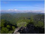
Polhograjska Grmada is an 898 m high peak located in the heart of the Polhograjski Dolomites. From the summit, where there is a registration box ...
2 h 10 min |
 | Dvor - Polhograjska Grmada (via Mala Grmada)
Polhograjska Grmada is an 898 m high peak located in the heart of the Polhograjski Dolomites. From the summit, where there is a registration box ...
1 h 45 min |
 | Preval - Polhograjska Grmada
Polhograjska Grmada is an 898 m high peak located in the heart of the Polhograjski Dolomites. From the summit, where there is a registration box ...
2 h 45 min |
 | Dvor - Polhograjska Grmada
Polhograjska Grmada is an 898 m high peak located in the heart of the Polhograjski Dolomites. From the summit, where there is a registration box ...
1 h 45 min |
 | Polhov Gradec - Tošč (via Grmada)
Tošč, which became the highest peak of the Polhov Gradec Hills decades ago when the Yugoslav army lowered Pasja ravan by 9 metres, is located nor...
2 h 30 min |
 | Polhov Gradec - Tošč (via Mačkov graben)
Tošč, which became the highest peak of the Polhov Gradec Hills decades ago when the Yugoslav army lowered Pasja ravan by 9 metres, is located nor...
1 h 50 min |
| Trnovec - Tošč
Tošč, which became the highest peak of the Polhov Gradec Hills decades ago when the Yugoslav army lowered Pasja ravan by 9 metres, is located nor...
1 h 35 min |
 | Petačev graben - Tošč (via Sveta Jedert)
Tošč, which became the highest peak of the Polhov Gradec Hills decades ago when the Yugoslav army lowered Pasja ravan by 9 metres, is located nor...
1 h 50 min |
 | Škofja Loka (Vincarje) - Lubnik (ridge path)
Lubnik is a 1025 m high mountain that rises steeply west of Škofja Loka. From the summit, where a mountain hut stands, there is a beautiful view ...
2 h 15 min |
 | Škofja Loka - Lubnik (via Stari grad)
Lubnik is a 1025 m high mountain that rises steeply west of Škofja Loka. From the summit, where a mountain hut stands, there is a beautiful view ...
2 h 15 min |
| Škofja Loka - Lubnik (via Luža)
Lubnik is a 1025 m high mountain that rises steeply west of Škofja Loka. From the summit, where a mountain hut stands, there is a beautiful view ...
2 h |
 | Praprotno - Lubnik
Lubnik is a 1025 m high mountain that rises steeply west of Škofja Loka. From the summit, where a mountain hut stands, there is a beautiful view ...
2 h 15 min |
 | Preserje - Krim
Krim is a 1,107-metre-high mountain rising south of the Ljubljana Marsh. From the summit, where a mountain hut and several transmitters stand, th...
2 h 20 min |
 | Dom v Iškem Vintgarju - Krim
Krim is a 1,107-metre-high mountain rising south of the Ljubljana Marsh. From the summit, where a mountain hut and several transmitters stand, th...
2 h 15 min |
 | Hunting cottage Plehanov laz - Krim
Krim is a 1,107-metre-high mountain rising south of the Ljubljana Marsh. From the summit, where a mountain hut and several transmitters stand, th...
2 h 15 min |
 | Dolenja Brezovica - Krim
Krim is a 1,107-metre-high mountain rising south of the Ljubljana Marsh. From the summit, where a mountain hut and several transmitters stand, th...
2 h 10 min |
 | Sopota - Kum (Nežina pot)
Kum, at 1,220 metres, is the highest peak in the Posavje Hills. As it rises above the Zasavje region, some call it the Zasavje Triglav. At the su...
2 h |
 | Cerknica - Slivnica
Slivnica is a 1,114-meter-high peak located north of the Cerknica Field and the intermittent Lake Cerknica. The summit itself is quite rounded, p...
1 h 40 min |
 | Loke - Krvavica (via Zajčeva koča)
Krvavica is a 909-metre-high peak located east of Čemšeniška planina. From the summit, which drops steeply on all sides, there is a beautiful vie...
2 h 10 min |
 | Razdrto - Vojkova koča na Nanosu (gentle path)
Vojkova koča is located on the southern edge of the high karst Nanos plateau, near Pleša. This is the prominent peak with television transmitters...
2 h 15 min |
 | Veliko Ubeljsko - Vojkova koča na Nanosu
Vojkova koča is located on the southern edge of the high karst Nanos plateau, near Pleša. This is the prominent peak with television transmitters...
1 h 50 min |
 | Vrčice - Mirna gora (via Škrilj)
Mirna gora is a 1047 m high, forested peak located on the southeastern edge of Kočevski rog. From the summit, which has a summit register and sta...
2 h 10 min |
| Vrčice - Mirna gora (via Planina)
Mirna gora is a 1047 m high, forested peak located on the southeastern edge of Kočevski rog. From the summit, which has a summit register and sta...
2 h 10 min |
 | Hotovlja - Pasja ravan
Pasja ravan is the second-highest peak in the Polhograjsko hribovje. A few decades ago, at 1029 meters, it was the highest, but in the second hal...
1 h 45 min |
 | Potoče - Potoška gora
This forested peak is situated above Preddvor, between Javorov vrh and the Iskra na Jakobu mountain hut. The summit has a bench and a registratio...
2 h |
 | Spodnja Kokra - Potoška gora
This forested peak is situated above Preddvor, between Javorov vrh and the Iskra na Jakobu mountain hut. The summit has a bench and a registratio...
2 h 10 min |
 | Selski most - Babji zob (via Kupljenik)
Babji zob is a viewpoint above the village of Kupljenik near Bled. The precipitous peak, which has a registration box, offers a beautiful view of...
2 h 40 min |
 | Gabrče - Vremščica
Vremščica is a mountain range stretching between Senožeče, Pivka and Divača. Its highest peak is Velika Vremščica. The view from the summit exten...
2 h |
| Senožeče - Vremščica
Vremščica is a mountain range stretching between Senožeče, Pivka and Divača. Its highest peak is Velika Vremščica. The view from the summit exten...
1 h 45 min |
 | Gornje Ležeče - Vremščica
Vremščica is a mountain range stretching between Senožeče, Pivka and Divača. Its highest peak is Velika Vremščica. The view from the summit exten...
1 h 40 min |
 | Podgora - Vremščica
Vremščica is a mountain range stretching between Senožeče, Pivka and Divača. Its highest peak is Velika Vremščica. The view from the summit exten...
2 h |
| Famlje - Vremščica
Vremščica is a mountain range stretching between Senožeče, Pivka and Divača. Its highest peak is Velika Vremščica. The view from the summit exten...
2 h 30 min |
 | Marija Reka (Strgar) - Mrzlica (permanently closed path)
In recent years, Mrzlica has become an extremely popular excursion spot, especially for visitors from Savinjska valley and Zasavje. At 1,122 mete...
2 h 30 min |
 | Matke - Mrzlica (via Počivalnik)
In recent years, Mrzlica has become an extremely popular excursion spot, especially for visitors from Savinjska valley and Zasavje. At 1,122 mete...
2 h 30 min |
| Podmrzlica, Matke - Mrzlica
In recent years, Mrzlica has become an extremely popular excursion spot, especially for visitors from Savinjska valley and Zasavje. At 1,122 mete...
1 h 45 min |
 | Matke - Mrzlica (past Kočet and on logging trail)
In recent years, Mrzlica has become an extremely popular excursion spot, especially for visitors from Savinjska valley and Zasavje. At 1,122 mete...
2 h 40 min |
 | Vrtovin - Mala gora
Mala gora is a plateau on the slope of Čavna. At 1034 meters' altitude, there is a hut. Mala gora is known for its flowers that are unique to thi...
2 h 20 min |
 | Gabrje - Trdinov vrh
Trdinov vrh is the highest point in the Gorjanci range. The view from the summit is poor due to the forest, but with good visibility, parts of th...
2 h |
 | Vitanje - Basališče (Paški Kozjak)
Basališče is the highest peak of Paški Kozjak. A bench and a summit register have been placed on the summit. However, due to the forest, there is...
2 h 30 min |
 | Gradišče - Kremžarjev vrh
Kremžarjev vrh is the westernmost thousand-meter peak on Pohorje. It is located northeast of Slovenj Gradec. From the summit, which has a logbook...
1 h 55 min |
| Slovenj Gradec - Kremžarjev vrh
Kremžarjev vrh is the westernmost thousand-meter peak on Pohorje. It is located northeast of Slovenj Gradec. From the summit, which has a logbook...
2 h 15 min |
 | Trojane - Črni vrh (Čemšeniška planina)
Črni vrh is the highest peak of Čemšeniška planina and, at 1,204 m, the second-highest peak in Posavsko hribovje. The summit has a logbook box bu...
2 h 45 min |
| Jelševica - Črni vrh (Čemšeniška planina)
Črni vrh is the highest peak of Čemšeniška planina and, at 1,204 m, the second-highest peak in Posavsko hribovje. The summit has a logbook box bu...
2 h 45 min |
 | Dolina Zaplaninščice - Črni vrh (Čemšeniška planina)
Črni vrh is the highest peak of Čemšeniška planina and, at 1,204 m, the second-highest peak in Posavsko hribovje. The summit has a logbook box bu...
2 h 30 min |
 | Podgorje - Slavnik (gentle path)
Slavnik is a panoramic mountain rising south of Kozina and west of Podgorje. Podgorje is a suitable starting village for the ascent. At the summ...
1 h 40 min |
 | Skadanščina - Slavnik
Slavnik is a panoramic mountain rising south of Kozina and west of Podgorje. Podgorje is a suitable starting village for the ascent. At the summ...
1 h 40 min |
 | Skadanščina - Slavnik (via Planina Jegno)
Slavnik is a panoramic mountain rising south of Kozina and west of Podgorje. Podgorje is a suitable starting village for the ascent. At the summ...
2 h 10 min |
 | Prešnica - Slavnik
Slavnik is a panoramic mountain rising south of Kozina and west of Podgorje. Podgorje is a suitable starting village for the ascent. At the summ...
2 h |
 | Povžane - Slavnik (via planina Jegno)
Slavnik is a panoramic mountain rising south of Kozina and west of Podgorje. Podgorje is a suitable starting village for the ascent. At the summ...
2 h 30 min |
| Povžane - Slavnik
Slavnik is a panoramic mountain rising south of Kozina and west of Podgorje. Podgorje is a suitable starting village for the ascent. At the summ...
2 h 15 min |
| Skadanščina - Slavnik (via planina Jegno)
Slavnik is a panoramic mountain rising south of Kozina and west of Podgorje. Podgorje is a suitable starting village for the ascent. At the summ...
2 h 25 min |
 | Slovenska vas - Sveta Trojica
Sveta Trojica is a distinctly panoramic 1106-meter peak located southwest of the Javorniki. From the summit, where a beautifully restored histori...
2 h 15 min |
 | Trpčane - Koča na Kozleku
The Koča na Kozleku mountain hut is situated southwest of Ilirska Bistrica, just a few meters below the summit of Kozlek. From the summit, there ...
1 h 45 min |
| Jablanica - Koča na Kozleku
The Koča na Kozleku mountain hut is situated southwest of Ilirska Bistrica, just a few meters below the summit of Kozlek. From the summit, there ...
1 h 45 min |
 | Rakov Škocjan - Veliki Javornik (Javorniki)
Veliki Javornik is a 1,268-meter-high peak of the forested hills named Javorniki. The extensive Javorniki forests stretch from Postojna to Cerkni...
2 h |
 | Ledinica - Sivka
Sivka is a forested peak located west of Žiri and north of Idrija. At the summit there is a stamp for the Slovenian Mountain Trail and a logbook ...
1 h 50 min |
| Žiri - Sivka
Sivka is a forested peak located west of Žiri and north of Idrija. At the summit there is a stamp for the Slovenian Mountain Trail and a logbook ...
2 h |
 | Žiri - Sivka (via Vrsnik)
Sivka is a forested peak located west of Žiri and north of Idrija. At the summit there is a stamp for the Slovenian Mountain Trail and a logbook ...
2 h 30 min |
 | Bohinjska Bela (Podklanec) - Galetovec (western way)
Galetovec is an indistinct peak on the southeastern part of the Pokljuka plateau. From the summit, which has a logbook, there is a nice view of t...
2 h |
| Brezje - Galetovec
Galetovec is an indistinct peak on the southeastern part of the Pokljuka plateau. From the summit, which has a logbook, there is a nice view of t...
2 h |
 | Bohinjska Bela - Galetovec (via Turn)
Galetovec is an indistinct peak on the southeastern part of the Pokljuka plateau. From the summit, which has a logbook, there is a nice view of t...
2 h |
 | Pongrac (Hostage cemetery) - Gozdnik (past Petelinov vrh)
Gozdnik is a hill that rises steeply above the village of Zabukovica. There is no view from the summit due to the forest, but a bivouac has been ...
2 h |
| Pongrac (Hostage cemetery) - Gozdnik (past Mali Gozdnik)
Gozdnik is a hill that rises steeply above the village of Zabukovica. There is no view from the summit due to the forest, but a bivouac has been ...
2 h 5 min |
 | Zgornja Rečica (church of Blessed Anton Martin Slomšek) - Malič
Malič is a 936-meter-high peak situated between Celje and Laško, more precisely above Spodnja Rečica. From the summit, which has a transmitter, b...
2 h 20 min |
 | Čretvež - Stolpnik (via Grofov štant)
Stolpnik, at 1012 meters, is the highest peak of Konjiška gora, a range stretching southwest from Slovenske Konjice. A 25-meter-high observation ...
1 h 35 min |
 | Žička kartuzija - Stolpnik (via Krniški rob)
Stolpnik, at 1012 meters, is the highest peak of Konjiška gora, a range stretching southwest from Slovenske Konjice. A 25-meter-high observation ...
2 h 30 min |
 | Črešnjice - Stolpnik (Črešnjice - Stolpnik - Sojek)
Stolpnik, at 1012 meters, is the highest peak of Konjiška gora, a range stretching southwest from Slovenske Konjice. A 25-meter-high observation ...
2 h 30 min |
| Stranice - Stolpnik (via Grofov štant)
Stolpnik, at 1012 meters, is the highest peak of Konjiška gora, a range stretching southwest from Slovenske Konjice. A 25-meter-high observation ...
2 h 25 min |
 | Stranice - Stolpnik (via hunting cottage Štepih)
Stolpnik, at 1012 meters, is the highest peak of Konjiška gora, a range stretching southwest from Slovenske Konjice. A 25-meter-high observation ...
2 h 15 min |
| Spodnje Stranice (graves of hundred hostages) - Stolpnik (via hunting cottage Štepih)
Stolpnik, at 1012 meters, is the highest peak of Konjiška gora, a range stretching southwest from Slovenske Konjice. A 25-meter-high observation ...
2 h |
| Spodnje Stranice (graves of hundred hostages) - Stolpnik (via Grofov štant)
Stolpnik, at 1012 meters, is the highest peak of Konjiška gora, a range stretching southwest from Slovenske Konjice. A 25-meter-high observation ...
2 h 10 min |
 | Frankolovo - Stolpnik
Stolpnik, at 1012 meters, is the highest peak of Konjiška gora, a range stretching southwest from Slovenske Konjice. A 25-meter-high observation ...
2 h 30 min |
 | Žička kartuzija - Stolpnik (via Sojek and Vratca)
Stolpnik, at 1012 meters, is the highest peak of Konjiška gora, a range stretching southwest from Slovenske Konjice. A 25-meter-high observation ...
2 h 10 min |
| Žička kartuzija - Stolpnik (via Tri križi and Vratca)
Stolpnik, at 1012 meters, is the highest peak of Konjiška gora, a range stretching southwest from Slovenske Konjice. A 25-meter-high observation ...
2 h 15 min |
 | Planina pri Sevnici - Skalica (Bohor) (via hunting lodge Bohor)
Skalica is a lesser-known peak on the western part of Bohor. From the summit, which has a logbook box, there is a nice view to the south and west...
2 h |
| Podgorje ob Sevnični (Kurja vas) - Skalica (Bohor)
Skalica is a lesser-known peak on the western part of Bohor. From the summit, which has a logbook box, there is a nice view to the south and west...
2 h 20 min |
 | Jablance - Veliki Javornik (Bohor) (via Koprivnik)
Veliki Javornik, at 1023 meters, is the highest peak of Bohor. Although the summit is unvegetated and there are no higher hills nearby, there is ...
2 h |
 | Stara Žaga - Veliki Javornik (Bohor) (via Skalica)
Veliki Javornik, at 1023 meters, is the highest peak of Bohor. Although the summit is unvegetated and there are no higher hills nearby, there is ...
2 h 10 min |
 | Planina pri Sevnici - Veliki Javornik (Bohor) (via hunting lodge Bohor)
Veliki Javornik, at 1023 meters, is the highest peak of Bohor. Although the summit is unvegetated and there are no higher hills nearby, there is ...
2 h 30 min |
| Planina pri Sevnici - Veliki Javornik (Bohor)
Veliki Javornik, at 1023 meters, is the highest peak of Bohor. Although the summit is unvegetated and there are no higher hills nearby, there is ...
2 h 30 min |
| Jablance - Veliki Javornik (Bohor) (via Koča na Bohorju)
Veliki Javornik, at 1023 meters, is the highest peak of Bohor. Although the summit is unvegetated and there are no higher hills nearby, there is ...
1 h 50 min |
| Šentvid pri Planini - Veliki Javornik (Bohor)
Veliki Javornik, at 1023 meters, is the highest peak of Bohor. Although the summit is unvegetated and there are no higher hills nearby, there is ...
2 h |
| Podgorje ob Sevnični (Kurja vas) - Veliki Javornik (Bohor)
Veliki Javornik, at 1023 meters, is the highest peak of Bohor. Although the summit is unvegetated and there are no higher hills nearby, there is ...
2 h 40 min |
 | Planina pri Sevnici - Koprivnik (Bohor)
Koprivnik, or Veliki Koprivnik, is one of numerous peaks on Bohor. It is located between Koča na Bohorju and Veliki Javornik. From the summit, wh...
2 h |
 | Pivola (Reka) - Mariborski razglednik (Cigelnica) (via Petkovo sedlo)
Mariborski razglednik (Cigelnica) is a 1,147-meter-high peak located by the Mariborsko Pohorje ski resort. A lookout tower on the summit offers m...
2 h 40 min |
 | Nova Štifta - Koča na Kamnem griču
The Koča na Kamnem griču mountain hut is located on Kamni grič, a panoramic hill rising southwest of Sodražica. From the grassy summit surrounded...
1 h 35 min |
 | Vrhnika pri Ložu - Racna gora
Racna gora is a little-visited peak rising east of Loška dolina. From the summit, which has a logbook box and stamp, there is no view due to the ...
1 h 45 min |
 | Sovodenj - Ermanovec (razgledna pot)
Ermanovec is a 1,026-meter-high peak situated between Cerkno and Gorenja vas, more precisely above Sovodenj and Trebija. Just a few steps from th...
2 h |
 | Kopačnica - Ermanovec
Ermanovec is a 1,026-meter-high peak situated between Cerkno and Gorenja vas, more precisely above Sovodenj and Trebija. Just a few steps from th...
1 h 40 min |
 | Hotavlje - Ermanovec (via Slajka)
Ermanovec is a 1,026-meter-high peak situated between Cerkno and Gorenja vas, more precisely above Sovodenj and Trebija. Just a few steps from th...
2 h 40 min |
 | Ljubenske Rastke - Bezovec
Bezovec is a lesser-known peak located in Smrekovško pogorje. From the summit, where a hunting observatory stands, a nice view opens up mainly on...
2 h 15 min |
 | Begunje (Krpin) - Smokuški vrh (by ski slope and via Sankaška koča)
Smokuški vrh is a panoramic mountain located on the ridge between the Završnica Valley and the Gorenjska plain. From the summit, where there is a...
1 h 40 min |
| Begunje (PGD Begunje) - Smokuški vrh (Petrova pot)
Smokuški vrh is a panoramic mountain located on the ridge between the Završnica Valley and the Gorenjska plain. From the summit, where there is a...
1 h 40 min |
 | Ribnica (Lepovče) - Stene svete Ane
Stene Svete Ane is a vegetated peak located near the Planinska Koča pri Sveti Ani on Mala Gora. A small observation tower stands on the summit, e...
1 h 35 min |
 | Ortnek - Stene svete Ane
Stene Svete Ane is a vegetated peak located near the Planinska Koča pri Sveti Ani on Mala Gora. A small observation tower stands on the summit, e...
2 h 30 min |
 | Gotenica - Goteniški Snežnik
At 1,289 meters, Goteniški Snežnik is the highest peak of Goteniška gora. The forested summit offers a somewhat obstructed view. It has a logbook...
2 h 45 min |
 | Ernejčkov graben - Sivka
Sivka is a grassy peak at the far western end of Polhograjsko hribovje. On clear days, it offers breathtaking views from Snežnik across Javorniki...
2 h |
 | Ljubljanica - Sivka
Sivka is a grassy peak at the far western end of Polhograjsko hribovje. On clear days, it offers breathtaking views from Snežnik across Javorniki...
2 h 25 min |
 | Kočevje - Mestni vrh (Grajska way)
Mestni vrh is a 1034 m high mountain located east of the Koča pri Jelenovem studencu hut. The summit, where there is a logbox with a stamp, offer...
1 h 40 min |
 | Kočevje - Livoldski vrh (Grajska way)
Livoldski vrh is a forest-covered hill located on the southeastern part of Stojna. The summit has a logbox and stamp....
1 h 45 min |
 | Kočevje - Požgani hrib (Kalan way)
Požgani hrib is a 1009 m high peak located in the heart of the extensive forests of Stojna. Mostly overgrown by forest, it offers only limited vi...
2 h |
| Kočevje - Požgani hrib (Grajska way)
Požgani hrib is a 1009 m high peak located in the heart of the extensive forests of Stojna. Mostly overgrown by forest, it offers only limited vi...
1 h 50 min |
 | Col - Križna gora (Hrušica)
Križna gora is a 1162 m high peak located north of the village Podkraj. From the summit, where a lookout tower stands, there are fine views over ...
2 h 20 min |
 | Col - Sveti Duh (Hrušica)
The Church of the Holy Spirit is located just a few meters below the summit of Sveti Duh on the slopes of the forested Hrušica, in the range betw...
2 h 15 min |
 | Bresternica (spodnji Rušnik) - Žavcarjev vrh
Žavcarjev vrh is a 915 m high mountain located north of the Drava River on the slopes of Kozjak. Since the summit is completely forested, there i...
1 h 40 min |
 | Jesenice (Ukova) - Španov vrh (Čez sedem grabnov)
Španov vrh is a 1334-meter-high mountain in the Karavanke that rises between Javorniški Rovt and Planina pod Golico. From the scenic summit, acce...
2 h 30 min |
 | Trdnjava Kluže - Kota 1313
Kota 1313 was an Austro-Hungarian artillery observation post during World War I. From position 1313, located near the indistinct summit of Veliki...
2 h 20 min |
 | Loke - Sveta planina (Partizanski vrh)
Sveta planina, also Partizanski vrh, is a 1,011-meter-high mountain located between Čemšeniška planina and Mrzlica. From the summit, where there ...
2 h 25 min |
 | Podbrdo - Kup
Kup is a 1,046-meter-high peak located between Petrovo Brdo and Podbrdo. From the summit, which features a cross and several transmitters, there ...
1 h 35 min |
 | Radlje ob Dravi - Kapunar / Kapunerkogel
Kapunar is a 1,051-meter-high peak above Radlje ob Dravi. Just below the summit stands an old customs post and border guardhouse, now used by ama...
2 h 15 min |
 | Radlje ob Dravi - Kapunar / Kapunerkogel (via Župank)
Kapunar is a 1,051-meter-high peak above Radlje ob Dravi. Just below the summit stands an old customs post and border guardhouse, now used by ama...
2 h 30 min |
| Radlje ob Dravi - Kapunar / Kapunerkogel (via old castle)
Kapunar is a 1,051-meter-high peak above Radlje ob Dravi. Just below the summit stands an old customs post and border guardhouse, now used by ama...
2 h 30 min |
 | Trojane - Špilk
Špilk is a 956 m high peak located north of Blagovica. At the mostly forested summit, PD Blagovica has set up a small bivouac with a bench and ta...
2 h 30 min |
 | Hotavlje - Štor (by road)
Štor is a 1005 m high peak located directly above the Koča na Ermanovcu hut. The summit itself is forested, but from a meadow just a few dozen me...
2 h 15 min |
| Trebija - Štor (via Ermanovec)
Štor is a 1005 m high peak located directly above the Koča na Ermanovcu hut. The summit itself is forested, but from a meadow just a few dozen me...
2 h 20 min |
 | Zgornja Besnica (Podrovnik) - Sveti Mohor (Zabrekve)
The Church of St. Mohor is located on a 952 m high hill between Zgornja Besnica and Selci. From the church or its nearby surroundings, there is a...
1 h 45 min |
 | Kopačnica - Škofje (via valley of Podkovščica)
Škofje is a 973-meter-high peak located above the villages of Čeplez, Planina pri Cerknem, and Podpleče. The summit itself, marked by a small con...
2 h 45 min |
| Dolenji Novaki (Pod Kovkom) - Škofje
Škofje is a 973-meter-high peak located above the villages of Čeplez, Planina pri Cerknem, and Podpleče. The summit itself, marked by a small con...
2 h |
 | Ledinica - Loncmanova Sivka (Mrzli Vrh)
Loncmanova Sivka is a panoramic peak above the village Mrzli Vrh near Žiri. From the bare summit, on clear days, there are views of Golaki, Škofj...
1 h 35 min |
 | Žiri - Loncmanova Sivka (Mrzli Vrh)
Loncmanova Sivka is a panoramic peak above the village Mrzli Vrh near Žiri. From the bare summit, on clear days, there are views of Golaki, Škofj...
1 h 40 min |
 | Žiri - Loncmanova Sivka (Mrzli Vrh) (via Vrsnik)
Loncmanova Sivka is a panoramic peak above the village Mrzli Vrh near Žiri. From the bare summit, on clear days, there are views of Golaki, Škofj...
2 h 40 min |
 | Vinska Gora - Ramšakov vrh (easy path)
Ramšakov vrh is the highest point of the circular path around Vinska Gora. At the 970 m high summit, next to the benches, there is also a stamp b...
2 h |
 | Vinska Gora - Ramšakov vrh (via farm Vodošek)
Ramšakov vrh is the highest point of the circular path around Vinska Gora. At the 970 m high summit, next to the benches, there is also a stamp b...
2 h |
 | Beli Potok at Frankolovo - Stenica
Stenica is a 1091-meter-high peak located between Vitanje, Stranice, and Frankolovo. The summit, which features a stamp, logbook, and bench with ...
1 h 45 min |
 | Tržič - Veliki vrh above Završnik (via Kamnek)
Veliki vrh above Završnik is a 968 m high mountain located in the Pirmance ridge, north to northeast of Tržič. From the grassy summit, which feat...
1 h 45 min |
| Tržič - Veliki vrh above Završnik (below Kamnek)
Veliki vrh above Završnik is a 968 m high mountain located in the Pirmance ridge, north to northeast of Tržič. From the grassy summit, which feat...
1 h 40 min |
 | Greuth - Große Muschenig (via Maria Elender Alm)
Veliki Mošenik or Große Muschenig in German is a 1021 meters high peak situated on the Austrian side of the Karawanks, more precisely between Bis...
1 h 45 min |
| Greuth - Große Muschenig (via Hasengraben)
Veliki Mošenik or Große Muschenig in German is a 1021 meters high peak situated on the Austrian side of the Karawanks, more precisely between Bis...
1 h 45 min |
 | Matrafuered - Kékestető (pot modri križ)
Mátra is a hill range located 70 km east of Budapest. It hosts Hungary's two highest peaks: Kékes/Kekes at 1,014 m, the highest point in Hungary,...
2 h |
 | Matrafuered - Kékestető (Marijina pot)
Mátra is a hill range located 70 km east of Budapest. It hosts Hungary's two highest peaks: Kékes/Kekes at 1,014 m, the highest point in Hungary,...
2 h |
 | Matrafüred - Kékestető (red path via Peresberc in Negyeshatar)
Mátra is a hill range located 70 km east of Budapest. It hosts Hungary's two highest peaks: Kékes/Kekes at 1,014 m, the highest point in Hungary,...
2 h 45 min |
 | Matrafüred - Kékestető (pot modri trikotnik)
Mátra is a hill range located 70 km east of Budapest. It hosts Hungary's two highest peaks: Kékes/Kekes at 1,014 m, the highest point in Hungary,...
2 h |
 | Matrafüred - Kékestető (zelena pot)
Mátra is a hill range located 70 km east of Budapest. It hosts Hungary's two highest peaks: Kékes/Kekes at 1,014 m, the highest point in Hungary,...
2 h 15 min |
 | Gorenja vas - Javorč (via Jermanca)
Javorč is a 901-meter-high peak located northeast of Žiri. The summit, featuring a logbox with a logbook, lies at the edge of a larger clearing, ...
2 h |
 | Planina pri Sevnici - Debeli vrh (Bohor)
Debeli vrh is a 921-meter-high peak on Bohor between Veliki Koprivnik and Oslica. Covered in dense forest, it offers no views. A marked hiking tr...
2 h 30 min |
| Jablance - Debeli vrh (Bohor)
Debeli vrh is a 921-meter-high peak on Bohor between Veliki Koprivnik and Oslica. Covered in dense forest, it offers no views. A marked hiking tr...
1 h 35 min |
 | Lovrenc na Pohorju - Hlebov vrh (Rdeči Breg)
Rdeči breg stretches between the Radoljna gorge to the east, the Drava to the north, and the Velka stream to the east. It is separated from the m...
2 h 10 min |
 | Lovrenc na Pohorju - Hlebov vrh (Rdeči Breg) (via Povh and Brabar)
Rdeči breg stretches between the Radoljna gorge to the east, the Drava to the north, and the Velka stream to the east. It is separated from the m...
2 h 30 min |
| Janževski Vrh (Uran) - Hlebov vrh (Rdeči Breg) (via Brabar)
Rdeči breg stretches between the Radoljna gorge to the east, the Drava to the north, and the Velka stream to the east. It is separated from the m...
1 h 40 min |
| Lovrenc na Pohorju - Hlebov vrh (Rdeči Breg) (via Kapus)
Rdeči breg stretches between the Radoljna gorge to the east, the Drava to the north, and the Velka stream to the east. It is separated from the m...
2 h 40 min |
 | Kočevje - Ledenik
Ledenik, at 1,072 meters, is the highest peak of Stojna, a forested ridge situated between Kočevje and Kočevska Reka. On the summit there is a lo...
2 h 15 min |
 | Rovte - Bela peč (Podbliška gora)
Bela peč is situated on the edge of Jelovica above the village Podblica. From the top of the cliff a beautiful view opens up towards the mentione...
2 h 45 min |
 | Paka pri Velenju - Visoko
Visoko is an easily accessible grassy plateau located south of Paški Kozjak. The summit features a monument to the fallen fighters of the 14th Di...
1 h 45 min |
 | Ledinica - Planinska koča Mrzl'k
The Planinska koča Mrzl'k mountain hut lies just a few meters below the Mrzlik summit. From the hut opens up a fine view of the neighboring Mrzli...
1 h 45 min |
| Žiri - Planinska koča Mrzl'k
The Planinska koča Mrzl'k mountain hut lies just a few meters below the Mrzlik summit. From the hut opens up a fine view of the neighboring Mrzli...
2 h |
 | Ledinica - Planinska koča Mrzl'k (via Jarčja Dolina)
The Planinska koča Mrzl'k mountain hut lies just a few meters below the Mrzlik summit. From the hut opens up a fine view of the neighboring Mrzli...
1 h 45 min |
 | Ravne na Koroškem - Šteharski vrh (Šteharnikov vrh)
Šteharski vrh (also Šteharnikov vrh or Črneška gora) is a 1,018 m high mountain located in the southeastern part of the Strojna range, between th...
1 h 45 min |
| Dravograd lake - Šteharski vrh (Šteharnikov vrh)
Šteharski vrh (also Šteharnikov vrh or Črneška gora) is a 1,018 m high mountain located in the southeastern part of the Strojna range, between th...
2 h 15 min |
 | Radlje ob Dravi - Bricnik
Bricnik is a 1,017-meter-high peak located in the Kozjak hills above Muta. On the forested summit there is a logbox with logbook and stamp (the K...
2 h 30 min |
| Dolina Radeljskega potoka (Razdevšek) - Bricnik
Bricnik is a 1,017-meter-high peak located in the Kozjak hills above Muta. On the forested summit there is a logbox with logbook and stamp (the K...
2 h 20 min |
| Dolina Radeljskega potoka (Razdevšek) - Bricnik (via Zavetišče Onuk - Glavar)
Bricnik is a 1,017-meter-high peak located in the Kozjak hills above Muta. On the forested summit there is a logbox with logbook and stamp (the K...
2 h 45 min |
 | Volča - Malenski vrh
Malenski vrh is a 1,051-meter-high mountain located west of the settlement of Javorje. The summit features a small bench and a cairn, but the vie...
1 h 45 min |
 | Rein - Mühlbacher Kogel (Hunting path / Jägersteig)
Mühlbacher Kogel is a 1,050 m high mountain in the western part of the Graz Mountains in Styria.It is located above the Mühlbacher Hütte hut.From...
2 h 10 min |
 | Rein - Mühlbacher Kogel (via Hochstein)
Mühlbacher Kogel is a 1,050 m high mountain in the western part of the Graz Mountains in Styria.It is located above the Mühlbacher Hütte hut.From...
2 h 30 min |
 | Hotavlje - Vrhovski grič (via Slajka)
Vrhovski Grič is a panoramic hill along the marked trail from Trebija to Ermanovec. From the grassy summit there is a fine view of the surroundin...
2 h 30 min |
 | Trebija - Vrhovski grič
Vrhovski Grič is a panoramic hill along the marked trail from Trebija to Ermanovec. From the grassy summit there is a fine view of the surroundin...
1 h 35 min |
| Trebija - Vrhovski grič (via Sveti Pavel)
Vrhovski Grič is a panoramic hill along the marked trail from Trebija to Ermanovec. From the grassy summit there is a fine view of the surroundin...
1 h 45 min |
 | Hotavlje - Špik (Vranškov grič)
Špik (also marked as Vranškov grič on maps) is a 908 m high mountain west of Hotavlje. The summit lies in forest, but a grassy subpeak offers fin...
1 h 35 min |
 | Deutschfeistritz - Schartnerkogel (on road)
Schartnerkogel is a 931-meter-high hill above the town Deutschfeistritz (Nemška Bistrica) in the western part of the Graz Mountains. A cross stan...
2 h |
 | Frohnleiten - Gschwendt (Gschwendtberg)
Gschwendt or Gschwendtberg is a 1,000-meter-high hill above the town of Frohnleiten in the eastern part of the Graz Mountains. Gschwendt has two ...
1 h 45 min |
 | Log - Ledinekov kogel
Ledinekov kogel is a 1,182-meter-high peak located north of Mariborska koča. Just below the summit there is a fenced area with a radar tower....
2 h 40 min |
 | Pivola (Reka) - Ledinekov kogel (eastern path)
Ledinekov kogel is a 1,182-meter-high peak located north of Mariborska koča. Just below the summit there is a fenced area with a radar tower....
2 h 40 min |
| Pivola (Reka) - Ledinekov kogel (western path)
Ledinekov kogel is a 1,182-meter-high peak located north of Mariborska koča. Just below the summit there is a fenced area with a radar tower....
2 h 45 min |
 | Stubenbergsee - Kulm (via Kulmkögerl)
Kulm is a 975-meter-high panoramic peak located west of the town of Weiz. From the summit, where several sacred structures stand, a beautiful vie...
2 h |
 | Frohnleiten - Haneggkogel (panoramic path)
Haneggkogel is a 1089-meter-high hill above the town of Frohnleiten in the northwestern part of the Graz Mountains.On the summit stands a cross a...
2 h |
 | Frohnleiten - Hochtrötsch (Trötsch)
Hochtrötsch, or simply Trötsch, is a 1,239 m high hill and a popular hiking destination above the town of Frohnleiten in the Graz Mountains. In t...
2 h 15 min |
 | Laufnitzdorf - Schiffall
Schiffall is a 1,221 m high peak in the Graz Mountains. Together with the neighboring Kreuzkogel, it rises above the middle Mur Valley north of F...
2 h 15 min |
 | Lišnjak (road on Promina) - Čavnovka (Promina) (past hut and on footpath)
Čavnovka is the highest summit of Promina, a smaller range above the town of Drniš. There are two summits: the southern one features an antenna, ...
1 h 45 min |
 | Lišnjak (road on Promina) - Čavnovka (Promina) (past hut and on road)
Čavnovka is the highest summit of Promina, a smaller range above the town of Drniš. There are two summits: the southern one features an antenna, ...
1 h 45 min |
 | Bruck an der Mur - Hochanger (on road)
Brucker Hochanger (Hochanger) is a 1308 m high mountain in the Gleinalpe area. Together with Rennfeld and Madereck, it is one of the three local ...
2 h |
 | Podgorje ob Sevnični (Kurja vas) - Ješivec
Ješivec (also Ješivc) is a 934-meter-high peak in Posavsko hribovje, from which a beautiful view opens up mainly to the south and west, while for...
2 h 45 min |
 | Podgorje ob Sevnični (Kurja vas) - Zaloška gora
Zaloška gora is a 930-meter-high panoramic peak on Bohor, from which a beautiful view opens up towards the east, south and partly west, while to ...
1 h 55 min |
 | Matke - Homič (past Kočet and on logging trail)
Homič is one of the peaks on the Prebold mountain trail, located northwest of the slightly higher and more famous Mrzlica. From the summit, where...
2 h 25 min |
| Matke - Homič (via Kočet and Kriška planina)
Homič is one of the peaks on the Prebold mountain trail, located northwest of the slightly higher and more famous Mrzlica. From the summit, where...
2 h 35 min |
 | Sošice - Ječmište (čez Pliješ)
Ječmište is a grassy summit above Žumberak, near Slovenia, on Žumberačka gora. The summit is an HPO point and part of the Karlovačke obilaznice. ...
2 h 30 min |
| Sošice - Ječmište (past Planinska koča Vodice)
Ječmište is a grassy summit above Žumberak, near Slovenia, on Žumberačka gora. The summit is an HPO point and part of the Karlovačke obilaznice. ...
2 h 15 min |